Arizona Winter Road Trip Itinerary for a Warm Week by RV
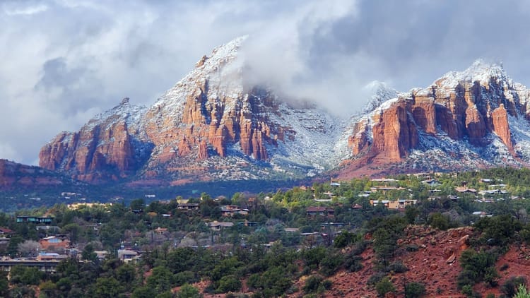
There's a version of January where you're scraping a windshield, and there's a version where you're standing outside a travel trailer at Lost Dutchman State Park in a T-shirt, coffee in hand, watching the Superstition Mountains go pink. Three hours north, the Grand Canyon is under a foot of snow. Same state, same morning. An RV is the only kind of travel that lets you pick which one you wake up in, and this Arizona winter road trip itinerary picks the warm one, with the snow kept as a day trip for anyone who wants to see red rock wearing white. Winter in Arizona is a question of elevation, and this Arizona road trip itinerary answers it the easy way: sleep low, drive high when you feel like it.
Seven days, clockwise out of Phoenix: a night at Lost Dutchman State Park under the Superstitions, two at Dead Horse Ranch State Park on the Verde River below Sedona, two at Catalina State Park on the edge of Tucson, a night out along Interstate 8 near Yuma, and a last one in open desert at the La Posa Long Term Visitor Area outside Quartzsite before the two-hour run home. About 750 miles. Every campground open all winter. No road driven twice.
Along the way: a gold mine nobody has found, a train that follows eagles up a canyon, a thousand-year-old apartment building, a hot dog worth driving to Tucson for, a prison with a river view, and a town that turns into a city every January. If you want the Grand Canyon in the middle of the week, the optional day below says how and what it costs you in degrees. Five days instead of seven? The cut is near the bottom.
Arizona Winter Is Two Seasons, and This Route Sleeps in the Warm One
Arizona winter depends entirely on how high you park. Phoenix sits near 1,100 feet. Tucson is about 2,400. The Verde Valley, where Cottonwood and Dead Horse Ranch are, is around 3,300, with Sedona twenty minutes up the road at about 4,300. Flagstaff and the South Rim are near 7,000. In January those five places are having five different months, and you choose your month by choosing a campground.
At the bottom, a January afternoon runs near 70 and the nights settle into the 40s. Shorts by day, a sweatshirt at the fire, and a smug text to whoever's shoveling back home. In Sedona the days are in the upper 40s and most nights freeze. On the rim, the days are in the low 40s, the nights are in the teens, and the snow is real: the South Rim averages somewhere between four and eight feet of it a season. So, does it snow in Arizona? Yes, a lot, above about 5,000 feet. Sedona gets a few dustings a winter. Phoenix essentially never.
For the RV, that column of numbers sorts itself into three rules. Below about 3,500 feet the water hose stays connected and the furnace is a courtesy. In the Verde Valley the furnace runs before dawn, and a propane level sensor on the tank beats the tap-it-and-guess method. On the rim it's winter camping, the kind our winter RV camping prep guide covers step by step, and this route only goes up there on purpose.
Five of the seven nights are in the low desert below 3,000 feet. The other two are in the Verde Valley at about 3,300. The cold day is yours to take or skip.
The Loop at a Glance: Seven Days, Four Base Camps, One Direction
Here's the Arizona itinerary as a map, for anyone with an Arizona road trip map open in the other tab. The week runs clockwise. North first, into red rock country and a river valley that was building pueblos long before Sedona had a name. Then south, back past Phoenix into saguaro country and the best food city in the state. Then west along the bottom edge of Arizona, where the traffic disappears and the lettuce fields begin, and north again past bighorn country to a town that spends its winters as the biggest campground on earth. Home is two hours east of there. In drive times: forty minutes to Lost Dutchman, two hours on to Cottonwood, four to Tucson on the one long day, four more to Yuma, ninety minutes to Quartzsite, two hours home. Every leg but one is under four hours, which leaves most afternoons for the thing you drove there for.
It's an Arizona bucket list disguised as a winter road trip, and it hinges on one reservation. Arizona State Parks opens its booking window a year out and caps any stay at fourteen nights in a thirty-day span, and the January weekends at Lost Dutchman and Catalina are the ones people set alarms for. Book those two the day the window opens. Everything else on the loop is first-come or permit-based and can bend around the weather, and it will.
Day 1: Phoenix in Winter, from Lost Dutchman State Park
Every campground has a story it tells at the fire. This one has a gold mine. Jacob Waltz was a German prospector, "the Dutchman" only because nobody in 1870s Arizona could tell the difference, and he was said to have found a mine somewhere in the Superstitions and hidden caches from it. He died in Phoenix in 1891 still dropping hints, and the park's own history notes that seekers in the years since have "sometimes met with foul play or even death." Nobody has found it. Plenty are still looking, which tells you something about the gold and more about the mountains.
They rise straight off the campground loop. Lost Dutchman State Park sits at the base of the Superstition Mountains forty miles east of Phoenix, close enough that the range fills the dinette window and far enough that you can't hear a single one of the metro area's millions. Walk the Siphon Draw Trail up toward the Flatiron in the morning, a climb that's a heat emergency in June and a T-shirt workout now. Spend the afternoon being a tourist at Goldfield, the rebuilt mining town just outside the park gate, where the saloon, the narrow-gauge train and the mine tour are exactly as corny as they should be. Twenty minutes farther up the Apache Trail the road drops to Canyon Lake, a reservoir folded into the cliffs with a steamboat on it, and people paddle it in January without anyone thinking that's strange. At dusk the whole range goes orange, then pink, then a purple that doesn't look real, and the only sound after dark is somebody two sites over failing to light a fire.
Phoenix in winter is the Valley's best season, and the campground is forty minutes from it. The Desert Botanical Garden is the place in the city where the desert is laid out and labeled, acres of cactus and wildflower trails in Papago Park, and in December it lights thousands of luminarias after dark. The Heard Museum holds one of the country's great collections of Native American art, and it's one of the few museums where the gift shop is a legitimate reason to go. The rest of Phoenix can wait for a trip when it isn't perfect outside.
The rules, and there aren't many. The park is open year-round, with electric and water at the hookup sites and no size restrictions on RVs. The dump station, in the park's own words, is not open to the public, so dump on the drive in or the drive out. Leashed dogs are welcome. Put a surge protector on the pedestal before the first plug-in; state-park power is fine most nights, and the night it isn't is the night that costs you a converter.
Days 2 and 3: Sedona and the Verde Valley, from Dead Horse Ranch State Park
Sedona is the postcard and the Verde Valley is where you sleep. The drive from Phoenix to Sedona is Interstate 17 north, and this route exits early, on State Route 260 to Cottonwood, where Dead Horse Ranch State Park sits on the Verde River at about 3,300 feet: a thousand feet lower and a few degrees warmer than Sedona, cottonwoods over the sites, the river close enough to hear from bed. Twenty minutes up State Route 89A and you're standing in front of the same view Sedona charges for.
Give Sedona a full day and start it late, because the red rocks are a sunset town. Walk the Bell Rock Pathway in the morning when the light is flat and the crowds are thin. Eat lunch at Tlaquepaque, the arts village built to look like an old Mexican town and now old enough to nearly be one. Climb up into the Chapel of the Holy Cross, a church wedged into the sandstone in the 1950s with a window that makes the rocks look like the altar. Then Cathedral Rock at the end of the day. Sedona sells its vortexes hard, spots where the earth's energy is said to spiral up through whoever's standing there, and whether or not you buy any of it, Cathedral Rock at sunset makes a persuasive case. A Red Rock Pass or an America the Beautiful pass is required to park at the forest trailheads, and a free shuttle runs to the big ones on set days, the answer for anything longer than a van. If Sedona is the trip you actually want, a Sedona road trip on its own is a different week, and a good one. For anyone who'd rather sleep in town, Rancho Sedona RV park is open year-round with full hookups, takes RVs to 45 feet, and welcomes dogs.
The other day belongs to the valley, and the valley was a city before Sedona was a word. The Sinagua built Tuzigoot on a ridge above the river, more than a hundred rooms that housed several hundred people for several centuries, and walked away from it in the 1300s. It sat empty until archaeologists dug it out in the 1930s. The loop trail through the rooms is a third of a mile, enough to stand on the roof of a thousand-year-old apartment building and look down at the river that fed it. Leashes and the monument's own rules for dogs in national parks apply. From there it's ten minutes to Clarkdale and the Verde Canyon Railroad, four hours in an open-air car through a canyon no road reaches, running all winter, and from January on the bald eagles are in the cottonwoods along the water, close enough that the whole car goes quiet. Spend the evening in Jerome, the copper town that hangs off Cleopatra Hill at an angle that has you checking the parking brake twice. It boomed, then all but emptied, and the people who moved into the empty storefronts turned them into galleries, tasting rooms and a saloon or two. The 1916 Douglas Mansion is its state historic park, and the view from its lawn takes in the whole valley you've been driving around. The Verde Valley grows wine now, and Cottonwood's Old Town has quietly turned into a row of tasting rooms, a good way to end a day that started in a pueblo.
On the way out, Montezuma Castle is twenty minutes south of Cottonwood, a Sinagua cliff dwelling set high in a limestone wall that was one of the country's first four national monuments in 1906, and the Park Service asks RVs to stay on the paved roads at the Well. Dead Horse Ranch's pull-throughs take 40-foot motorhomes and truck-and-trailer combinations to 65 feet, with water and 30/50-amp service, open all year. This is also where the hose first comes inside at night on this loop. A heated water hose turns that from a nightly chore into a thing you did once.
Subscribe to our weekly newsletter.
WHERE THE RV SLEEPS WARM IN ARIZONA THIS WINTER. FREE, EVERY WEDNESDAY.
The Optional Cold Day: The Grand Canyon South Rim from the Verde Valley
If you want snow on red rock, this is where it goes: a day or an added night, not a stop in the sequence. In winter the South Rim does something it never does in July. The canyon fills with cloud from the bottom up, whites out completely, and empties again while you stand at Mather Point with four other people and your breath hanging in front of the view. Snow on the rim, bare rock a mile down, and the summer crowds gone home. It's a little over two hours north of Cottonwood up Interstate 17 and State Route 64 through Williams, open every day of the year, and at 7,000 feet it is real winter.
Mather Campground takes RVs to 30 feet with no hookups all winter. Trailer Village, the park's only place to plug in, is still shut from the August 2026 flood and isn't expected back, in phases, until after Thanksgiving 2026, so Williams, an hour south of the rim, is where an RV with a power cord sleeps for the Grand Canyon in winter this season. Hermit Road opens to private vehicles under 22 feet in December, January and February, the only three months you can drive it yourself. Trailer Village's usual place is in our list of national parks with RV hookups, and when the rim road goes back to shuttle-only in March, Utah's Mighty 5 by RV is where the same RV goes next.
The run from Sedona to Grand Canyon and back adds a full day and takes the overnight low from freezing to the teens. Top off the propane in Cottonwood before you climb. Anyone starting this leg from the city instead has the Phoenix to Grand Canyon road trip, a four-hour climb up Interstate 17, and anyone who'd rather give the canyon a night than a day is really on the Phoenix, Sedona and Grand Canyon itinerary, a three-stop week with its own rhythm.
Days 4 and 5: Tucson from Catalina State Park, with Picacho Peak on the Way
Tucson is the city on this loop that deserves the extra day, and the drive from Phoenix to Tucson is the loop's one four-hour leg to get there: back down Interstate 17 and out Interstate 10 to the southeast, flat and fast and a little dull. Two stops turn it into a day instead of a drive.
Casa Grande Ruins near Coolidge is the first. The Great House is a building of desert mud raised by the ancestral Sonoran Desert people around 1350, and it has been standing in the open for more than six centuries, which is longer than most things made of concrete will manage. In 1892 President Harrison set aside the square mile around it as the first prehistoric and cultural reserve the United States ever created, and it has stood under a steel shelter roof since 1932. Twenty minutes, then back on the freeway, and you'll be thinking about it for the next hundred miles.
Picacho Peak State Park is the second, right on Interstate 10. It's the peak you've seen from the freeway your whole life and never pulled off for, the site of what's usually called the westernmost battle of the Civil War in 1862, and in a wet spring the state's best wildflower hill, when the poppies turn the whole base of it orange. The trail to the top is short, steep, and strung with cables where the rock gets serious. The campground is electric-only with no water or sewer at the sites, has no maximum RV size, and has an off-leash dog park for campers, which makes it the alternative night if Catalina is full. It's also the flattest campground on the loop; Catalina's pads aren't always level, so keep leveling blocks where you can reach them.
Then Tucson, from Catalina State Park. The park protects the base of the Santa Catalina Mountains on the north edge of the city, and the trails leave from the back of the campground, so the day's hike starts where you parked. Romero Canyon runs up through a saguaro forest into the foothills, the mountains go pink about the time the saguaros go black against them, and a January afternoon here is sixty-five and windless, which is the exact temperature at which nobody wants to go inside. The campground is open all year with electric and water at the hookup sites, there's no limit on RV length, and an overflow loop with no hookups opens for the winter when the main loops fill. Book it anyway. Overflow is where the people who didn't set the alarm sleep.
Saguaro National Park gets the first day: the cactus forest on the edge of the city where the saguaros stand forty feet tall and older than the state, and the Cactus Forest Loop at golden hour is the drive people mean when they say Arizona. The park has, in the Park Service's own words, "no accommodations for any vehicle camping (including RV)", so you sleep at Catalina and drive in. Most of the parks in our guide to RVing in national parks work the same way. The second day is the Arizona-Sonora Desert Museum, part zoo, part botanical garden, all outside, where in the cool months the raptors are flown loose over the crowd and a Harris's hawk will pass close enough to part your hair. The museum's own directions say to avoid Gates Pass Road in any kind of RV. Come in from the south.
Between them, eat. Tucson was the first city in the country named a UNESCO City of Gastronomy, and the case rests on the Sonoran hot dog: bacon-wrapped, buried in pinto beans, onions, tomato and a stripe of mayo, served from a cart or a strip-mall window, and worth the four-hour drive on its own. Mission San Xavier del Bac, the white Spanish church on the reservation south of the city that has been standing since the 1790s, is the other stop every visitor makes and none of them regret. And for anyone who wants both of Arizona's winters in one afternoon, the Catalina Highway climbs from the saguaros near the campground to snow on top of Mount Lemmon in about an hour. For the free nights within an hour of the city, our guide to desert boondocking in Arizona has the specifics.
Day 6: Interstate 8 to Yuma, the Border Side of the Loop
Nobody plans a trip around Interstate 8. That's the case for it. West on Interstate 10 to Casa Grande, then Interstate 8 toward Yuma across the emptiest stretch of the loop: Gila Bend, the bombing range to the south, the Gila River somewhere off to the right, and the oldest art in Arizona sitting a few miles off the highway.
Painted Rock Petroglyph Site is a low hill of dark boulders west of Gila Bend, covered in hundreds of figures carved into the rock centuries ago, and you can walk right up to them: bighorn, lizards, spirals, people with their arms raised, and nobody knows for certain what any of it meant. The Bureau of Land Management runs a campground beside it, dirt and gravel that the BLM calls suitable for big motorhomes and fifth wheels when the roads are dry, with no hookups and no reservations. It's the optional sixth night, for anyone who'd rather sleep under petroglyphs than in a city, and after dark the sky out here is the one the carvers had. When it's rained, keep going.
Yuma is the warmest place on the loop and the winter-lettuce capital of the country, so the fields on the way into town are being cut as you drive past and lunch is a farm stand where the salad was in the ground this morning. Get a date shake from one of the date farms outside town. Then the Territorial Prison, on its bluff above the Colorado River: opened in 1876 with the first prisoners building their own cells, thirty-three years of stagecoach robbers, a famous woman bandit named Pearl Hart, and a view from the guard tower that hasn't changed. It's a state historic park now, and it takes an hour you won't want back. Walk down to the river after. This is the Colorado near the end of its work, slow and green between the levees, and the restored wetlands along it fill with herons in winter.
For anyone already on a BLM long-term permit, the Imperial Dam Long Term Visitor Area just north of town on the California side honors the same permit as La Posa. Otherwise the night is Painted Rock or one of Yuma's RV parks. Either way, this is where the fresh tank starts to matter, since the next two nights may have a faucet and may not, and a gravity water filter on the counter makes a campground spigot taste like nothing at all.
Day 7: Quartzsite, Arizona, and the La Posa LTVA
North on US 95 from Yuma, ninety minutes of creosote flats with mountains on both sides and almost nobody coming the other way. About halfway is Kofa National Wildlife Refuge, set aside in 1939 for desert bighorn sheep, and holding in Palm Canyon the only palms native to Arizona, a grove tucked into a slot so narrow the sun only finds them at midday. The trail is half a mile from the end of a dirt road. The refuge's own page says most of its roads are unmaintained and many need four-wheel drive, and that there are no facilities and no drinking water anywhere on it, so a big RV admires Kofa from the highway and a small one goes in slowly. Camping is allowed on the refuge, with vehicles within a hundred feet of the road and no site within a quarter mile of water. Bring big binoculars. The bighorn are on the ledges above the canyon more often than you'd think, and they're better at spotting you than you are at spotting them.
Then Quartzsite, Arizona, a town whose founding father has a camel on his grave. Hadji Ali was a Syrian-born camel driver the US Army hired in 1857 for its experiment in crossing the desert on camels. When the camels were retired he prospected around here, and died in 1902. The town put a pyramid with a copper camel on his grave in 1935, and it's still the first thing people visit. Everyone calls him Hi Jolly.
What Quartzsite is in winter is a town of a few thousand that becomes one of the largest cities in the state every January, nearly all of it on wheels. The highway frontage turns into miles of tents selling rocks, gems, turquoise, solar panels, tools and things that defy category, and the nine-day Quartzsite RV show in mid-January, the Big Tent, is the reason half of them came and the excuse the other half needed. Walk it once. Buy something you don't need from a man who has been setting up the same booth since the Reagan administration. Then drive two miles south and the noise stops.
Quartzsite boondocking is the reason most of them are here. The BLM's La Posa Long Term Visitor Area, the La Posa LTVA on every sign, is open desert south of town on US 95 where a permit is required inside the boundaries during the winter season, mid-September to mid-April, and where that permit buys water faucets, a dump station, trash service and toilets. Two permits exist, one for the whole season and one for any fourteen consecutive days, and either works at every LTVA the BLM runs. Outside the boundaries the regular BLM camping rules apply: dispersed camping generally limited to fourteen days in any twenty-eight, free, no services, and no shortage of it.
This is a tank-math night, so work out how long you can boondock before you pick a spot, because the best spots are the ones farthest from the faucet. A solar generator and a panel cover a week of it if the fridge is on propane; an RV solar setup on the roof covers the season. The people who stay the season are the snowbirds, and the desert gets quieter the farther you get from the pavement, until the lights after dark are yours and a scatter of strangers', all of them politely far away. Somebody will wander over in the morning with coffee and an opinion about where you should have parked instead.
The drive home is two hours east on Interstate 10. The loop is closed, the tanks are full of the wrong things, and you've spent a week of January in a T-shirt.
Arizona in December, Arizona in February, and the Weeks in Between
Arizona in December has the low desert at its best and the high country getting its first real snow, which makes it the month to do this loop exactly as written. The week between Christmas and New Year's is the crowded stretch at the state parks, and it's the busy week up on the rim, too; if the holidays are your window, the year-ahead booking is the way in. Arizona in February is the warmest of the three winter months, the desert starting to green, wildflowers possible at Picacho by the end of the month in a wet year, and the Quartzsite crowd thinning after the show. The month between is the coldest and the emptiest, and the best for the low desert, and Arizona in January is its own story by elevation.
On the shoulders: November is warm and uncrowded and the loop works, but the Verde Valley nights are already cold. March is spring break, the state parks fill, the desert blooms, and the rim road goes back to shuttle-only. Winter rain, when it comes, is a day or two of Pacific storm and then a week of sun, and the state's road-conditions site is the morning check for Interstate 17 in any month, since that freeway climbs out of the desert on the way north and the top of it sees weather the bottom never does.
The Five-Day Arizona Itinerary, and Other Ways to Cut the Loop
The five-day Arizona itinerary drops the Yuma leg, and yes, that stings. Phoenix for a night, the Verde Valley for two, Tucson for two, then Interstate 10 straight west to Quartzsite for a last night if the show is on, or straight home. The three-day version is one base camp and its day trips, and there are ten of those in our Arizona weekend getaways. The ten-day stretch adds the canyon as two nights in Williams and a second night under the petroglyphs at Painted Rock. If you have a second week in the same season, Death Valley in winter is one state over.
The loop runs counter-clockwise just as well for anyone starting in Tucson or coming in from California on Interstate 10, in which case Quartzsite is night one and the Verde Valley is the finish.
Either way, the week ends where it started: a January morning, a T-shirt, the Superstitions going pink, and the snow three hours north that you did or didn't go see. The road trips from Phoenix are a long list, and most of them are shorter than this one. Our national parks for RV camping in the West list is where the same season goes next, and the campground closures and reopenings that change a loop like this land in Swervia Weekly on Wednesdays, usually before the operator page catches up.
The Short Version
- Seven days, clockwise: Phoenix, the Verde Valley, Tucson, Yuma, Quartzsite, home. About 750 miles.
- Four base camps, all open all winter: Lost Dutchman (no RV size limit), Dead Horse Ranch (pull-throughs to 65 feet), Catalina (no length limit), La Posa (a permit, water and a dump).
- Five nights in the low desert below 3,000 feet, two in the Verde Valley around 3,300. The snow starts near 5,000 and the route stays under it.
- Book Lost Dutchman and Catalina the day the window opens, a year out.
- The Grand Canyon is optional and cold: Mather to 30 feet with no hookups, Trailer Village closed until after Thanksgiving 2026.
- Five days: skip Yuma. Ten days: add two nights in Williams.
FAQs
Does it snow in Arizona?
Yes, a lot, above about 5,000 feet. Flagstaff and the Grand Canyon's South Rim get real winter, with several feet of snow over a season, and the rim's nights run in the teens. Sedona, at about 4,300 feet, gets a few dustings a winter that rarely last a day. Phoenix, Tucson and Yuma essentially never see it. This route sleeps below the snow line for all seven nights and treats the canyon as an optional day trip, which is how an RV gets both winters in one week.
When does winter start in Arizona?
In the low desert, winter in Arizona is the stretch from November to March when afternoon highs settle into the 60s and 70s and nights drop into the 40s, and it is the best weather of the year in Phoenix, Tucson and Yuma. In the high country, winter starts with the first snow, usually in November or December, and runs into March. On this loop, December through February is the window, with November and March as workable shoulders that trade a little warmth for a lot fewer people.
How cold does Arizona get in the winter?
It depends on elevation more than on the calendar. Phoenix, Tucson and Yuma see nights in the 40s and afternoons near 70. Sedona, at about 4,300 feet, freezes most January nights, with days in the upper 40s. Flagstaff and the South Rim, near 7,000 feet, run in the low 40s by day and the teens at night. Above about 4,000 feet the water hose comes inside at night and the furnace runs before dawn; below 3,500 feet it stays connected all week.
Can you camp for free in Arizona in the winter?
Yes. On Bureau of Land Management land the general rule is dispersed camping for up to fourteen days in any twenty-eight-day period, free, with no services. Around Quartzsite the BLM's Long Term Visitor Areas are different: inside their boundaries a permit is required during the winter season, mid-September to mid-April, and the permit buys water faucets, a dump station and trash service. A season-long permit or a fourteen-day short-visit permit both work at every LTVA the agency runs, including Imperial Dam near Yuma.
Is a week enough for an Arizona road trip?
Yes. This loop is about 750 miles with four base camps and only one driving day over four hours, and it covers the Sonoran Desert, the Verde Valley, Sedona, Tucson, the Colorado River and Quartzsite. Five days is enough if you drop the Yuma leg and run Interstate 10 straight from Tucson to Quartzsite. Ten days adds the Grand Canyon as two nights in Williams. Three days is one base camp and its day trips, not a loop.
Can you take an RV to the Grand Canyon on this trip?
Yes, as an optional cold day from the Verde Valley. The South Rim is open all year and sits at 7,000 feet, a little over two hours north of Cottonwood. Mather Campground takes RVs to 30 feet with no hookups all winter. Trailer Village, the park's only full-hookup campground, is closed after the August 2026 flood with a phased reopening planned after Thanksgiving 2026, so this season the plug-in base is Williams, an hour south of the rim. Hermit Road opens to private vehicles under 22 feet in December, January and February only.
Where do RVers go in Arizona for the winter?
The low desert, in roughly this order of warmth: Yuma, Quartzsite, Phoenix and Tucson. Yuma is the warmest and the winter-produce capital of the country. Quartzsite is the one that becomes a city, with RVs across the BLM desert around the La Posa Long Term Visitor Area and a nine-day RV show in mid-January. Phoenix and Tucson have the state parks with hookups and no RV length limits, Lost Dutchman and Catalina, which book a year out. Where to go in Arizona in winter is mostly a question of how far below 3,500 feet you want to sleep.
Categories
Related Posts
Subscribe to the Swervia Newsletter
The best RV stories, tips, and destinations—expertly curated and always free.