Death Valley Itinerary: 4 Winter Days Built for an RV
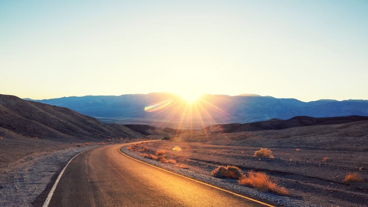
Stand at Dantes View on a January morning and the lowest point in North America is directly under your boots. A white ribbon of salt a vertical mile down, 11,000-foot mountains stacked across from you, the whole valley going pink at once. It's the first stop on nearly every Death Valley itinerary you'll find.
In a 34-foot fifth wheel, you can't get there. The road up bans vehicles over 25 feet, and not one of those itineraries says so, because they were written for a rental sedan out of Las Vegas.
Come anyway. Death Valley in winter is the strangest good week of driving in the country: a basin 282 feet below sea level, salt flats you can walk out onto until the people behind you shrink to specks, sand dunes 200 miles from the nearest ocean. In July it's the hottest place on Earth and the heat closes trails. In January it's shirt-sleeve mild and nearly empty, which makes it the rare national park you can visit in the dead of winter without it feeling like an act of stubbornness.
So this is four days ordered around what the park's own rules let a big vehicle drive. The restricted roads get a day of their own, the wide-open drives land on the days you're already moving, and you find out which is which before you're committed to a canyon with nowhere to turn around. Plan it in that order and it's one of the best national parks for RV camping in the West.
Why Winter Is Death Valley's Season
The same geometry that makes Death Valley lethal in summer makes it comfortable in winter. The valley floor sits below sea level, walled in by mountains, with almost no moisture in the air. Sinking air compresses and heats, the walls trap it, and there's no humidity or cloud cover to blunt it. In July that machine produces temperatures that close trails. From late fall through early spring, it idles: days on the valley floor are shirt-sleeve mild, and the light on the badlands goes soft and gold in a way summer visitors never see.
Ask a ranger about the best time to visit Death Valley and you'll get some version of the same answer: the cool months, roughly October into April. Death Valley in November has a particular sweetness to it, with summer's heat gone and the holiday crowds not yet arrived. Deeper into winter, the trade-off is daylight. You get about ten hours of usable light in December, and the good light comes at the edges of it. That's why this itinerary puts one big thing in the morning and one in the afternoon instead of cramming five stops into a day that ends at half past five.
The other half of the deal: nights get genuinely cold. The desert runs both seasons in the same 24 hours, and your RV will notice. More on that below.
Where to Base the RV: Furnace Creek and the Alternatives
Death Valley is the largest national park in the Lower 48, at 3.4 million acres, most of it mountain and gravel. Where you park the RV shapes every day of the trip, because the stops are 20 to 60 miles apart and there's no looping back for a forgotten lunch.
Furnace Creek Campground is where most RV trips here are based, and the reasons are practical. It sits mid-park, close to Badwater, Zabriskie Point and Artists Drive, and it's the only National Park Service campground in Death Valley with full hookups: a short row of sites with power, water and sewer in a park where electricity is otherwise something you brought with you. It's also the reservable one, through recreation.gov, and in winter you should treat that reservation like a fixed cost of the trip: this is the season everybody comes, and the hookup sites go first. Desert campground water travels a long way to reach a spigot, so an inline water filter is cheap insurance between the tap and your tanks.
Mesquite Spring, at the quiet north end, is a different trip entirely: no hookups, big spacing, and some of the darkest night sky in the country overhead. You trade the outlet for the silence, and you put yourself 20 minutes from Ubehebe Crater instead of two hours. If your batteries and tanks can carry you, it's the connoisseur's pick.
Stovepipe Wells puts you at the dunes end of the valley, with an NPS campground that's mostly a gravel lot and, more usefully for a big RV, a small private RV park across the road with hookups and a year-round season. Panamint Springs Resort, on the park's west side, is the base for anyone arriving from the Sierra rather than from Vegas. It makes the long western approach the best drive of the trip. If this is your first long haul into the desert West, our guide to your first RV trip out west covers the distances-and-services mindset that makes it comfortable.
There's also the option of sleeping outside the park entirely. Death Valley RV Park sits in Beatty, Nevada, on US-95 about an hour from Furnace Creek by way of Daylight Pass, and it trades a scenic campsite for full 50-amp hookups, a dump station, showers and a town you can walk to for dinner. The bonus is the burros. Wild burros have roamed Beatty since the mining days, and they wander the streets and the campground with no particular urgency and no fear of people. Watch them, photograph them, and don't feed them. They're wild animals, and the town has spent years asking visitors to keep it that way.
Two housekeeping notes before you commit. Emigrant Campground has been closed for water-system work, and generators are prohibited at Texas Springs, which matters if you planned to run off batteries and top up with a generator rather than book a hookup site. Both are the kind of thing to confirm on the park's campground pages when you book.
Subscribe to our weekly newsletter.
THE NATIONAL PARK ROADS YOUR RV CAN ACTUALLY DRIVE. FREE, EVERY WEDNESDAY.
The Roads Your RV Can't Drive in Death Valley
Read this before you plan a single day, because it's the rule the car-trip itineraries never mention: Death Valley prohibits vehicles longer than 25 feet (or wider than 9 feet) on four roads (Dantes View Road, Artists Drive, Emigrant Canyon Road and Lower Wildrose Road) and recommends the same limit for Twenty Mule Team Canyon. The reason is easy to picture once you've seen the terrain: these are narrow, winding corridors cut through badlands and canyon, with tight radii and nowhere to turn a big vehicle around once you're committed.
Between Dantes View and Artists Palette, that's two of the park's signature views sitting behind a length limit. This itinerary is built around that fact. The restricted roads get their own day, placed where you can reach them with whatever solution fits your setup, and the wide-open drives land on the days you're moving anyway. Death Valley isn't unusual here, only strict. Our breakdown of RV size limits in Yellowstone shows the same pattern in a very different landscape, and it's a standard chapter in RVing in national parks generally.
Closures matter as much as the limits, and here they're permanent weather, not a bad year. Flash floods tear out Death Valley's roads on their own schedule and the park rebuilds them on a much slower one, so something signature is almost always shut. Titus Canyon Road has spent much of the past decade in one phase of flood repair or another. Scotty's Castle has been closed for flood recovery for years. Darwin Falls closes and reopens for the same reason.
Plan for it. Assume at least one headline stop will be shut the week you go, build the four days so no single one depends on a single road, and check the park's current conditions page before you leave, the way you'd check highways to avoid in an RV on the drive in. One more desert habit worth adopting: the distances are long, the shoulders are gravel, and pavement temperatures swing hard between a cold morning and a warm afternoon, so a tire-pressure monitor stops being a gadget and starts being how you find out about a slow leak before mile 40 does.
Day 1: Badwater Basin and the Valley Floor
Get parked, get level, and go stand below sea level. Badwater Basin is a 17-mile drive south of Furnace Creek and the lowest point in North America at 282 feet down, the floor of a lake that mostly evaporated thousands of years ago and is still finishing the job. What it left behind is a plain of salt crusted into honeycomb polygons that crunch underfoot, stretching white toward the Panamint Range. Walk out past the boardwalk crowd, ten or fifteen minutes onto the flat, until the people behind you shrink to specks. In winter you can do this at noon in a light jacket, standing in a spot that would be an emergency by August. It's the single most memorable thing in the park.
On the way back, pull off at Zabriskie Point. A short paved ramp climbs from the lot to a view over golden badlands folded like drapery, with the salt flats and the mountains stacked behind them. This ground was mined for borax in the 1880s before anyone thought to just look at it; the view made the place famous, and the low winter sun is exactly what it wants. Come at the start or end of the day and the folds throw shadows that flatten to nothing by midday.
Day 2: Mesquite Flat Sand Dunes and Ubehebe Crater
Mesquite Flat Sand Dunes rise right off the road near Stovepipe Wells: a hundred feet of rippled, photogenic sand with mountains behind every sightline and not an ocean for 200 miles. The dunes exist because this corner of the valley is a trap: wind carries sand off the eroding mountains, hits a wall of rock, and drops its cargo in the same place, century after century. There's no trail because none is needed. Walk toward whichever ridge looks best, and go at the edges of the day, when the light rakes sideways and every ripple casts a shadow. The interior dunes hold nobody's footprints but yesterday's wind.
Then drive north, into the emptiest and longest sightlines in the park. The famous stop up here, Scotty's Castle, a 1920s Spanish-style mansion with a story built on a con man's charm, has been closed for flood recovery for years, so check before you count on it. What's worth the drive regardless is Ubehebe Crater: 600 feet deep and half a mile across, blasted out in an instant when rising magma hit groundwater and the steam went off like a bomb. You park essentially on the rim and look straight down into it. Walk the rim loop if the wind lets you, and it frequently has opinions up here. If you based at Mesquite Spring, you're 20 minutes from camp and can be back for an early dinner under a sky with no light pollution in any direction.
Day 3: Artists Palette and Dantes View
Two of the must-see stops in Death Valley sit at the end of roads with the 25-foot limit, so this is the day that takes planning instead of just driving. Both stops repay it.
Artists Drive is a nine-mile, one-way paved loop through hills stained in colors that look Photoshopped from the main road and better up close: pink, green, violet and gold, all of it volcanic ash whose minerals oxidized in different directions. The pull-off at Artists Palette is the concentrated dose. The colors are real, they're strongest in low-angle light, and the loop's dips and curves are most of the reason for the length limit.
Dantes View is the payoff of the whole trip. The road climbs to 5,475 feet, and from the rail you look more than a vertical mile straight down at Badwater Basin: the exact white flat you stood on two days ago, now a salt ribbon at the bottom of a trench, with Telescope Peak's 11,049 feet facing you across it. On a clear winter day it's the best single view in the park and one of the best in the desert West. Bring a real jacket; you've climbed a mile of elevation, and the summit air runs 20-plus degrees colder than the valley floor.
Round out the day with Twenty Mule Team Canyon, an unpaved one-way loop through bare yellow badlands near Zabriskie Point where the borax wagons once ran. The same length recommendation applies, and the road threads the hills tightly enough that you'll see why.
Day 4: Golden Canyon, Harmony Borax Works, or the Road West
If you have a fourth full day, spend the morning in Golden Canyon, a walk-in from an ordinary paved lot off Badwater Road with no vehicle restriction involved. The canyon narrows between golden walls to the base of Red Cathedral, a rust-colored cliff that glows when the sun finds it, and links with Gower Gulch into a loop of about four miles through the same badlands you admired from Zabriskie Point, now at arm's length. In winter this is a shirt-sleeve walk; in summer it's a closed oven.
Then close the story you've been walking through all week at Harmony Borax Works, just north of Furnace Creek. In the 1880s, crews scraped borax off the salt flats here and hauled it 165 miles to the nearest railhead behind teams of twenty mules. The wagons still sit at the site, and they're bigger than you're imagining. Every strange thing you've seen this week, from Zabriskie's mined hills to the canyon the wagons threaded, connects back to this modest pile of adobe and iron.
Or point the trip west instead: the exit through Panamint Springs climbs out of the valley toward the Sierra, past Father Crowley Vista Point and its plunging view into Rainbow Canyon, and gives the drive home one more good day in it.
What Winter in the Desert Does to an RV
Nobody under-prepares for cold like a traveler headed to the hottest place in America. The days are mild. The nights are not. Valley-floor lows can approach freezing, higher campgrounds drop well past it, and the swing between a warm afternoon and a cold night can run 40 degrees. Everything in our winter RV camping prep guide applies here, minus the snow.
Three systems feel it first. Batteries deliver noticeably less usable power in the cold, right when the furnace fan draws more of it. At Mesquite Spring with no hookups, a battery monitor is the difference between knowing your overnight margin and guessing at it. The furnace itself burns propane at a rate that surprises people who've only camped in summer, and the nearest refill is a mountain range away, so a propane tank sensor beats the knock test. And the same windows that let the afternoon sun pour in all day let the cold pour back in all night; reflective window insulation works both shifts.
Beyond the cold: this is dust country, distances between services are long even by Western standards, and fuel stops inside the park are few. Arrive with fresh water and fuel topped off and tanks empty, the way you'd stage for boondocking. Our desert boondocking guide covers the water math and the habits that make desert camping feel routine.
Bringing a Dog to Death Valley
The dog rules here are more restrictive than most people expect, and it's better to know before the dog is in the truck. Pets are allowed within 50 feet of roads and developed areas, and in campgrounds (up to four per site), but they're prohibited on trails and in wilderness, which is most of what you'll want to walk. Practically, that means your dog can join you at the overlooks, on the campground loop, and along the road corridors, but not out on the dunes or up Golden Canyon. The full rules live on the park's regulations page. Winter is the one season the wait in the RV is safe and comfortable, which is its own quiet argument for coming now rather than in April.
The Case for January
The same week your neighbors are draining their water lines and shrink-wrapping the boat, you could be standing on the floor of an evaporated lake in a light jacket, watching shadows move across badlands that took six million years to fold. There are more things to do in Death Valley than four days holds: backcountry roads, spring wildflower years, canyons this route never reached. A plan built around the rules on day one is a plan with no bad surprises in it, the same way our Yellowstone RV trip itinerary turned that park's sprawl into a route. For a weekly dose of trips like this one, timed to when they're actually drivable, Swervia Weekly shows up every Wednesday.
The Short Version
- Season: October through April. Mild days, cold nights, short daylight, so plan one big stop per morning and afternoon.
- Base camp: Furnace Creek for hookups and reservations (book early); Mesquite Spring for quiet and dark skies, no hookups; Stovepipe Wells for the dunes; Panamint Springs for a Sierra-side approach.
- The rule: vehicles over 25 feet (or 9 feet wide) are prohibited on Dantes View Road, Artists Drive, Emigrant Canyon Road, and Lower Wildrose Road; same limit recommended for Twenty Mule Team Canyon.
- Closures: assume one signature stop is shut. Titus Canyon Road, Scotty's Castle and Darwin Falls all close for flood repair on the park's schedule, not yours. Check current conditions before you leave.
- Day 1: Badwater Basin and Zabriskie Point. Day 2: Mesquite Flat Sand Dunes and Ubehebe Crater. Day 3: Artists Palette, Dantes View, Twenty Mule Team Canyon. Day 4: Golden Canyon and Harmony Borax Works, or exit west through Panamint Springs.
- Dogs: roads, overlooks and campgrounds only, never trails or wilderness.
FAQs
Can you drive an RV to Dantes View?
Only if the whole vehicle is 25 feet or shorter. The National Park Service prohibits vehicles over 25 feet long or 9 feet wide on Dantes View Road, along with Artists Drive, Emigrant Canyon Road, and Lower Wildrose Road, because the roads are narrow and winding with no room to turn a large vehicle around. A shorter Class B or C clears the limit; a large motorhome or trailer combination doesn't, so plan Dantes View for a day when you can get there under 25 feet.
Is Death Valley good to visit in winter?
Winter is the best season Death Valley has. The heat that makes the park dangerous in summer disappears from roughly October into April, leaving mild days that make the salt flats, dunes, and canyons genuinely walkable at midday. The trade-offs are short daylight, about ten hours in December, and nights that can approach freezing on the valley floor and drop below it at higher campgrounds. It's also the season when the rest of the country's camping shuts down, which makes it one of the few big national park trips an RVer can take in January.
How many days do you need in Death Valley?
For an RV trip, four days is the honest number. The park covers 3.4 million acres, stops are 20 to 60 miles apart, and the 25-foot length limit on Dantes View Road and Artists Drive means those signature stops have to be arranged around your setup rather than driven through on the way to something else. Two-day itineraries work for a car out of Las Vegas; once you've moved an RV into the valley, four days lets you cover the floor, the dunes, the north end, and the restricted-road views without any of it feeling like a checklist sprint.
Where can you camp in an RV in Death Valley?
Furnace Creek Campground is the hub: centrally located, reservable through recreation.gov, and the only NPS campground in the park with full hookups. Mesquite Spring at the quiet north end has no hookups but exceptional dark skies and space. Stovepipe Wells has an NPS campground plus an adjacent private RV park with hookups, and Panamint Springs Resort covers the park's west side. Emigrant Campground is closed for water-system repairs, and generators are prohibited at Texas Springs, which matters if you planned to camp without hookups and recharge by generator.
Can you bring a dog to Death Valley?
Yes, with real limits. Dogs are allowed within 50 feet of roads and developed areas, and in campgrounds with a maximum of four pets per site, but they're prohibited on all trails and in wilderness, which covers the dunes, the canyons, and nearly every walk in this itinerary. Overlooks reached from a parking lot, campground loops, and road corridors are fine. Winter's mild temperatures are the one season a short wait in the RV is safe, which makes it the best time to bring a dog here at all.
Is Titus Canyon Road open?
Often not. Titus Canyon Road is one of Death Valley's most flood-prone routes and it has spent much of the past decade closed for repair, reopening between phases of work and closing again after the next storm. Treat it as a bonus, not a fixture. Check the Death Valley current conditions page in the week before your trip and plan the day so the itinerary still works if the road is shut.
Why is Death Valley called Death Valley?
A party of gold-rush emigrants crossed the valley in the winter of 1849 after a shortcut to the California goldfields went badly wrong. They spent weeks trapped on the valley floor, burned their wagons to cure oxen meat, and walked out over the mountains; the story goes that one of them looked back from the pass and said "Goodbye, Death Valley." The name stuck. The grim footnote is that they crossed in winter, the season this itinerary covers, which is the only reason the name isn't literal more often in the story.

Related Posts
Subscribe to the Swervia Newsletter
The best RV stories, tips, and destinations—expertly curated and always free.