Phoenix to Grand Canyon Road Trip: The Direct Route, Driven in an RV
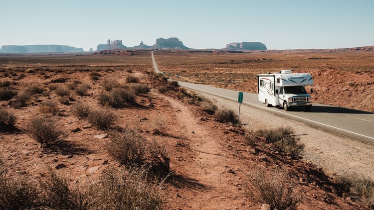
The map says four hours. The map has never driven anything heavy up I-17. It's a bit over 230 miles from Phoenix to the Grand Canyon's South Rim, and in a car the drive does take a little over four. Give it five in an RV. The Phoenix to Grand Canyon road trip is a climb, not a cruise, and the next section explains what 5,700 feet does to a vehicle that's also your bed.
This is the direct run: I-17 north out of the desert, one stop that's worth the exit, a night in Williams or Tusayan, and the rule on the rim roads that most drivers learn at the gate. If you want Sedona's red rocks in the middle, you're right to want them, and the Sedona version of this trip is its own article. If you want the whole week, the Arizona winter road trip itinerary folds this drive into a route across the state. And if you typed "Skywalk," that's Grand Canyon West, on a different road out of Kingman, and this isn't it.
Why the Direct Run Starts With a 5,700-Foot Climb
Phoenix sits at about 1,100 feet in the Sonoran Desert. Grand Canyon Village sits at about 6,800 feet in ponderosa pine. I-17 does most of that in one afternoon: out of the saguaros above Black Canyon City, then up again past Camp Verde onto the high country. You leave in a T-shirt and arrive in the season you drove south to avoid.
An RV feels all of it. The speed limit becomes a suggestion the grade overrules, so the drive runs slower than the map says. Tire pressures set on a warm Phoenix morning read differently at 7,000 feet in the cold, and the drop off the rim on the way home heats the brakes and the tires in the other direction; a tire-pressure monitor tells you what's happening on all of them without pulling over. Fuel goes faster uphill. And a November night in Williams is a furnace night, every night, with the water hose either heated or drained.
The rim you're driving to is the South Rim, the one that's open all year. What it's like once the snow arrives is its own story, and our guide to the Grand Canyon in winter covers it. This is the road.
Phoenix to Flagstaff on I-17: Rock Springs Pie and the Climb Out of the Desert
Black Canyon was a trail before it was a highway: a Yavapai camp, then a water stop for miners and cattle drives, then a stagecoach road. The last Black Canyon stagecoach was retired about 1917 as motor cars took over the trail, and a 19-year-old named Ben Warner put up a canvas-covered store to sell to the drivers who replaced it. That store became Rock Springs Cafe, which may be the oldest independently owned restaurant in Arizona. It's still there, right off the interstate about 45 minutes north of Phoenix. Still selling pie.
Stop. A slice at a table older than the highway is a better first hour than another 45 minutes of saguaros.
The Phoenix to Flagstaff leg does nearly all of the climbing, and it starts here. From Black Canyon City the interstate gains about 2,000 feet in 20 miles to Sunset Point, the mesa-edge rest area that ADOT calls the most popular in the state. It serves both directions from the southbound side, and the view back down the canyon you just climbed is the first place the trip feels like one. Past Cordes Junction the desert quits: Camp Verde in the valley, then the long pull up to Munds Park at 6,500 feet, the first ponderosa, and Flagstaff.
In winter the road is the hazard, not the grade. A storm on I-17 backs the interstate up for hours. Check az511.gov before you leave Phoenix, and if the board at Sunset Point shows Flagstaff in the red, stop in Camp Verde for the night and drive up in the morning.
Montezuma Castle National Monument, and Why Camp Verde Is the Overnight
About 900 years ago the Sinagua built a five-story, 20-room home into a limestone alcove about 90 feet up a cliff above Beaver Creek, lived in it for a couple of centuries, and walked away before Columbus sailed. Settlers in the 1860s assumed Aztecs and named it for an emperor who never saw it. In 1906 Theodore Roosevelt made it one of the first four national monuments in the country.
Why go: you stand at the base of the cliff on a paved third-of-a-mile trail and look up at an apartment building that was already old when Jamestown was founded. Ten minutes of walking, a whole afternoon of thinking about it. Montezuma Castle National Monument sits just off I-17 at Camp Verde, the one detour on this route that costs almost no time.
Camp Verde is the overnight, and not only for the Castle. It sits where the desert ends and the second climb begins, the natural place to split the drive. Distant Drums RV Resort is open all year with full hookups, concrete pads and pull-throughs long enough for anything on the road, plus a heated pool for the evening and a free shuttle to the casino next door, which also takes overnight RVs in its lot. Set up there, see the Castle from there, and start the next morning already halfway up the state.
Montezuma Well, a separate unit a few miles north, is a limestone sinkhole with a lake in it. The park's own warning is to stay on paved roads, because GPS will happily route an RV onto backcountry dirt to get there. Follow the signs, not the phone. And if Camp Verde isn't a night for you, it's a lunch stop by the same logic: the Castle and a fill-up, then the hill.
Subscribe to our weekly newsletter.
ARIZONA ROADS AND CAMPGROUNDS THAT TAKE AN RV IN WINTER. FREE, EVERY WEDNESDAY.
Williams or Flagstaff: Where the RV Sleeps Before the Rim
Two towns, half an hour apart, each about an hour from the rim, and one recommendation.
Flagstaff first. At 7,000 feet it's the big-town option, every service and a mountain over its shoulder. Ten minutes east on I-40, Walnut Canyon National Monument is the Sinagua again, cliff rooms under a limestone ledge, reached by a stair-step trail into the canyon and back out. The park recommends 40 feet as a maximum vehicle length and warns there's nowhere to turn an oversized vehicle around if you arrive after the gate closes. Go in the middle of the day, and don't let the GPS send you down Forest Road 303. It's dirt.
Williams is the recommendation. It was the last town on Route 66 that the interstate bypassed, in 1984, after years of court fights against six miles of I-40, and it kept three exits and its neon downtown as the price of surrender. The Grand Canyon Railway ran its first train to the rim in 1901, quit in 1968, and came back in 1989. The Grand Canyon Railway RV Park is next to the depot: open all year, full hookups at 30 and 50 amp, pull-throughs to 65 feet and back-ins to 55, a pet resort on site, and guest access to the hotel's indoor pool and hot tub. Two blocks from Route 66. Walk to the train in the morning and the RV never goes up SR 64 at all if you'd rather it didn't.
It snows here, around six feet a year, and November nights run in the 20s. That's a furnace-all-night town, so arrive with propane and a plan for the water: a heated water hose if you're staying hooked up, or fill the tank and unhook before dark. The rest of our winter RV camping prep guide applies at this elevation. The dog, meanwhile, has better lodging than most of the humans on this route, and our guide to dogs in national parks explains why that's convenient tomorrow.
Williams to the South Rim on SR 64, and the Rim's 22-Foot Rule
The last hour is SR 64 north through the Kaibab National Forest, 60 miles of ponderosa and open park that give no hint of a hole in the ground until Tusayan, the gateway town a mile outside the South Entrance. Then the gate. Then the rim.
Once you're in, the park's RV page sets the terms. Anything over 22 feet, or any vehicle-and-trailer combination over 22 feet, counts as oversized. Oversized parking is in three named lots: the Visitor Center lot, the Market Plaza lot for RVs 30 feet and under, and the lot on the west side of the village near the Backcountry Information Center. Not the others. They fill, so arrive early, and the free Village shuttle connects all three to the rim.
Yaki Point and the South Kaibab Trailhead are shuttle-only every day of the year. Hermit Road, the seven-mile rim drive west of the village, is the one people get backwards. It's closed to private vehicles from the start of March through the end of November, when the Red Route shuttle runs it. In December, January and February the shuttle stops, and the road opens to private vehicles under 22 feet. A short Class B clears it. A 32-foot Class C doesn't, in any month. The road can also shut on short notice for snow and black ice, so check the park's road status the morning you plan to drive it.
Twenty-two feet is the number to carry around the rim. It's the same pattern as the RV size limits that shape Yellowstone, and it's the reason the overlooks along Hermit Road in January are the quietest on the South Rim. Bring a wearable camp blanket; the wind off the canyon in winter goes straight through a Phoenix jacket.
RV Camping on the Grand Canyon South Rim: Mather Campground, Trailer Village and Tusayan
Can you camp at the Grand Canyon in an RV? Yes, three ways: inside the park at Mather Campground if you're under 30 feet and self-contained, inside the park at Trailer Village with hookups, or a mile outside the gate in Tusayan.
Mather Campground is the experience. It's open all year, set in the pines a walk from the rim, with a 30-foot maximum on RVs and no hookups. Sites are reserved through recreation.gov, with a handful held first-come. If you fit, this is where you walk to the rim before the day visitors arrive. Bring leveling blocks; the forest sites weren't graded by anyone who owned a fifth wheel.
Trailer Village next door is the park's only full-hookup RV park, with 30 and 50 amp, water and sewer, and paved pull-throughs to 50 feet, and in a normal year it runs year-round. It belongs on the short list of national parks with RV hookups, with one caveat. In late August 2026 a flash flood in Bright Angel Canyon killed three hikers and destroyed much of the pipeline that supplies the South Rim's water. The park has rationed water since, closed Trailer Village until further notice, and run Mather as dry camping only, with services phasing back as the line is repaired. Read the park's operations page before you count on a site inside the park.
Tusayan is the fallback that doesn't feel like one. Grand Canyon Camper Village is open all year, a mile south of the entrance, with full hookups at 30 or 50 amp and dry sites for the overflow. It sits at 7,200 feet, where winter nights go well below freezing, and campers report the water hookups get shut off on the coldest nights. Arrive with a full fresh tank and you won't notice. The national forest outside Tusayan allows dispersed camping in the trees, on the terms in our guide to national forest camping rules.
So the base-camp logic is short. Under 30 feet and happy on batteries: Mather, and book it the day the window opens. Anything bigger, or anything that wants a hookup in November: Williams for the town and the train, Tusayan for the one-mile gate.
The Way Back: Desert View Drive to Cameron, or Straight Down I-17
You can leave the way you came, or you can make it a loop.
The loop runs east. Desert View Drive follows the rim 23 miles from the village to Desert View, past overlooks where the canyon opens toward the Painted Desert, and ends at the Watchtower: Mary Colter's 70-foot stone tower, finished in 1932 and built to look like the Ancestral Puebloan towers that predate it by centuries. From its base the river is a mile down and the far rim ten miles off; a pair of long-range binoculars turns that wall into individual cliffs. The drive stays open all year unless snow and ice close it, and a few of the smaller overlook lots are tight for a long vehicle, so pick the big ones. Then out the East Entrance, 25 miles to Cameron on the Navajo Nation, and US 89 south to Flagstaff, past the Sunset Crater and Wupatki loop if the day allows: 35 paved miles around a cinder cone that erupted around 1085 and the red-stone pueblos people built in its ash over the century that followed.
The reader continuing north from Cameron is on the road to Page and Utah's Mighty 5 by RV. The reader heading west to Death Valley in winter is on I-40.
The direct exit is SR 64 back to Williams, I-40 east, I-17 south, and the whole climb in reverse. From Flagstaff to Phoenix the road drops more than a mile, most of it in two long descents. Don't let it. Gear down before Sunset Point, not after, let the engine hold the speed, and check the tires when you stop for the second slice of pie; a portable inflator makes that a five-minute job in the lot. You'll be back in the saguaros before the pie is gone. Back in the T-shirt, too.
One Road, One Climb, One Number
The Phoenix to Grand Canyon drive is a single interstate, a single state highway, and 5,700 feet of climb between a desert and a rim that gets snow. Plan the night in Williams, plan the pie, and carry 22 feet around in your head once you're up there. The rim rules are one park's version of the pattern in our planning guide to RVing in national parks, and the rest of the state fits around this drive; the multi-day Arizona plan lays out which direction to go next. The rest of Arizona in winter arrives on Wednesdays, one drive at a time, in Swervia Weekly.
The Short Version
- The route: I-17 north to Flagstaff or I-40 west to Williams, then SR 64 north to the South Rim. About 230 miles, five hours in an RV.
- The climb: Phoenix at about 1,100 feet to a rim near 7,000. Slower than the map, colder than the forecast, and check az511 before you leave in winter.
- The stop: Rock Springs for pie, Montezuma Castle for 900-year-old architecture, Camp Verde for the night if you're splitting the drive.
- Base in Williams: Grand Canyon Railway RV Park, open all year, full hookups, pull-throughs to 65 feet, and a train to the rim. Tusayan if you want the one-mile gate.
- Inside the park: Mather Campground, 30 feet and no hookups; Trailer Village with hookups, closed after the 2026 flood until the park says otherwise.
- The 22-foot rule: three named RV lots, Yaki Point shuttle-only all year, and Hermit Road open to private vehicles under 22 feet in December, January and February only.
- Sedona is its own trip. The direct run doesn't go through it; the three-stop version of this drive is the article for that.
FAQs
How far is the Grand Canyon from Phoenix, and how long does the drive take?
About 230 miles from central Phoenix to the South Rim by way of I-17, I-40 and SR 64. The Phoenix to Grand Canyon drive time is a little over four hours in a car. In an RV, plan on five: the road climbs about 5,700 feet between the two, the grades out of Black Canyon City and above Camp Verde run slower in a heavy vehicle, and Rock Springs is 45 minutes in and sells pie. In winter, add whatever ADOT's boards say I-17 is adding that day.
Can you do the Grand Canyon as a day trip from Phoenix?
People do, in a car: leave before dawn, drive four and a half hours, spend two or three on the rim, drive home. That's nine hours of driving for a couple of hours on the canyon, which is why a Grand Canyon day trip from Phoenix is the version people remember for the drive. In an RV the answer is Williams the night before. The RV park there is open all year with full hookups, the rim is an hour up SR 64, and you reach the overlooks before the day-trippers do.
What is the best stop between Phoenix and the Grand Canyon?
Montezuma Castle National Monument at Camp Verde, a five-story Sinagua cliff dwelling about 90 feet up a limestone wall, reached by a paved third-of-a-mile trail right off I-17. Rock Springs Cafe in Black Canyon City is the other one, for pie at a counter that's been feeding this road since 1918. Sedona isn't on the direct route; it's a detour on SR 179 and 89A that turns a five-hour drive into a two-day trip, and it deserves the two days, in the three-stop article built around it.
Is the drive from Phoenix to the Grand Canyon hard in an RV?
Not hard, just long and uphill. I-17 is an interstate the whole way to Flagstaff, and the climb is steady grade, not switchbacks; the slow lane and patience handle it. Weather and brakes are the two things to plan around. A winter storm on I-17 backs the road up for hours, so check az511 before you leave Phoenix. And the return trip drops more than a mile from Flagstaff to the desert, so gear down early and let the engine do the braking.
Can you drive Hermit Road in an RV?
Only in December, January and February, and only if the whole vehicle is under 22 feet in total length. From the first of March through the end of November the road is closed to private vehicles and the park's free Red Route shuttle runs it. In winter the shuttle stops and the road opens to vehicles under 22 feet, which covers a small Class B and most cars and excludes nearly every trailer combination. It can also close on short notice for snow and ice.
Where is the best RV base for the Grand Canyon South Rim?
Williams, an hour south on SR 64, for most RVs: the Grand Canyon Railway RV Park is open all year with full hookups, pull-throughs to 65 feet, a pet resort and a train to the rim next door. Tusayan, a mile outside the gate, is the choice when you want to be first at the overlooks. Mather Campground inside the park works if you're under 30 feet and don't need hookups; Trailer Village is the in-park hookup option in a normal year.
Does it snow on the drive from Phoenix to the Grand Canyon?
Not in Phoenix, and rarely below Camp Verde. From the climb past Munds Park onward, yes: Williams alone averages around six feet of snow a year, and the South Rim at nearly 7,000 feet gets real winter, with snow on the rim trail and ice on the roads. The drive itself is plowed interstate and state highway. What closes it is a storm in progress, so the answer to "will it snow" is ADOT's travel-time boards and az511 the morning you leave.
Categories
Related Posts
Subscribe to the Swervia Newsletter
The best RV stories, tips, and destinations—expertly curated and always free.