Must-See Death Valley National Park: 10 Sights Worth the Drive, in Valley Order
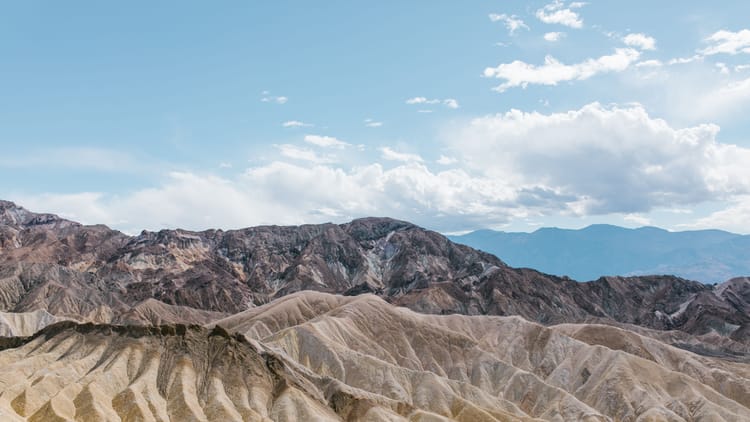
Every must-see Death Valley list is the same ten places, and that isn't laziness. A century of visitors have voted, and the winners are the spots that don't look like anywhere else on the continent: a salt flat below sea level, hills the color of a paint store, a crater you park on the lip of, a view straight down a vertical mile. You'll drive an hour or two between them, because Death Valley is bigger than Connecticut and keeps its highlights at opposite ends, and you won't mind, because the road between any two of them is a sight of its own.
What the lists leave out is a number. Five of the park's roads are closed to anything over 25 feet, towed length included, and two of the ten, Dantes View and Artists Palette, sit at the end of them. So the must-see Death Valley highlights below are ranked the way everyone ranks them, Badwater and Zabriskie on top, then laid out in the order the road hands them to you, and each one ends with the fact that settles whether your RV parks there or you find another way in.
In valley order, the Death Valley National Park must see list runs Badwater Basin, Natural Bridge and the Devils Golf Course, Artists Palette, Golden Canyon, Zabriskie Point, Dantes View, Harmony Borax Works, Salt Creek, the Mesquite Flat Sand Dunes and Ubehebe Crater. The hikes, the dark sky and the ghost town are a different kind of list, and things to do in Death Valley is where they live. Go in the cool season, roughly November into March, when the salt is walkable at noon; when to visit Death Valley sorts the months. And if you'd rather these ten came with nights attached, the Death Valley winter itinerary puts them into four days with the RV parked in the right place.
How This Death Valley List Is Ordered, and Why Twenty-Five Feet Matters
The places to see in Death Valley sort themselves by road, so drive the list top to bottom and you've driven the park: south down Badwater Road for the first four, back up to Zabriskie and Dantes off CA-190 just east of camp, west past the borax works and Salt Creek to the dunes, and north on pavement to the crater.
The five roads the park closes to vehicles over 25 feet long or 9 feet wide are Dantes View Road, Artists Drive, Emigrant Canyon Road, Lower Wildrose Road and Twenty Mule Team Canyon, and the length counts everything you're towing. Everything else on the list comes with a paved lot built for buses and large RVs or a short gravel spur the park rates as typically fine for an ordinary car. Big western parks tend to draw a line like this somewhere; Yellowstone's version is in our guide to RV size limits on its roads.
Dogs stay within 50 feet of a road or a developed area and never go on a trail or onto the dunes, even carried, so the overlooks are fine and the walks aren't; our guide to dogs in national parks has the park-by-park version. And base camp for most of this is Furnace Creek, the one campground in the park with hookups, which put it on our list of national parks with RV hookups. Pack leveling blocks, and give a tire-pressure monitor more respect here than in most parks: the gravel spurs are sharp and the nearest tire shop is a mountain range away.
1. Badwater Basin, the Lowest Point in North America
Badwater Basin is the bottom of the continent, 282 feet below sea level, and it's the bed of a lake that dried up thousands of years ago and never quite finished doing it. What the water left is salt, dried into a tile floor of ragged hexagons that give underfoot with a sound like breaking crackers. Walk out from the boardwalk and the polygons get cleaner and whiter and the people behind you get smaller. The park calls it a mile to the edge of the flat. There's no reason to stop there.
Then turn around. High on the cliff of the Black Mountains behind the lot, far above where you'd think to look, a small sign marks sea level. Everyone finds it eventually, and everyone goes quiet for a second.
The lot is paved, with spaces sized for RVs and buses, and an accessible ramp leads down to the boardwalk. Come back after dark if you're camped nearby. Death Valley is a Gold Tier dark sky park, the salt flat is one of the darkest corners of it, and a pair of astronomy binoculars gets more use in that lot than at any campground you've ever parked in.
2. Natural Bridge and the Devils Golf Course
Walk up a dry wash for half a mile and a slab of rock about 35 feet high and 35 feet thick is suddenly over your head, with canyon on both sides and sky through the middle. Natural Bridge is what floods do when they change their minds: they spent thousands of years cutting this canyon, shifted course, dropped the floor, and came back to the old channel underneath a piece they never got around to removing. It's a mile round trip with 86 feet of climb, and on the way back north from Badwater it pairs with the Devils Golf Course as the two things water does in this valley, one on the way in and one on the way out. The unpaved Natural Bridge Road turns off Badwater Road about 13 miles south of the highway, and the park rates it typically passable to a sedan.
The Devils Golf Course is what water does when it leaves. An old lakebed evaporated down to a plain of halite crystals so jagged you'd turn an ankle in three steps. Hold still for a minute and the whole plain ticks, crystals clicking and snapping as the sun warms them. Photograph it from the edge, where the crystals are sharpest. It sits at the end of a short gravel spur off Badwater Road.
3. Artists Palette, at the End of a Road With a Limit
Artists Drive leaves Badwater Road for nine one-way miles and climbs into hills that don't look like they should be that color. Pink, green, gold, a violet that photographs as fake and isn't. The hills are volcanic ash, and the metals in it, iron oxides and chlorite among them, weathered in different directions over a few million years. Rust, in six colors. The Artists Palette pullout about halfway through is where the colors stack closest together, and low light at either end of the day is when they're strongest. At noon they wash out to pastel.
The road is closed to anything over 25 feet or 9 feet wide, towed length included, because of the sharp bends and the dips, and it's one way, so once you're in you're driving all nine miles. Anything under the limit fits. Anything over sees the same hills from Badwater Road, where they read as a pink smudge across the valley, and knows what it's missing.
4. Golden Canyon and Red Cathedral, the One You Walk Into
Golden Canyon is the one sight on this list you have to walk into to see. From a paved lot off Badwater Road, a dry wash climbs between walls the color of toast and pinches tighter with every bend until Red Cathedral, a rust-red cliff, closes the far end and lights up when the sun gets on it. From Zabriskie Point these are the hills in the postcard; down here they're walls, lake sediments laid down before the valley existed, then tilted and cut. Three miles round trip gets you to Red Cathedral and back; the Gower Gulch loop runs 4.3 miles through more of the same country.
There's no vehicle restriction at either trailhead and the lots are paved. Carry more water than the distance suggests, and carry it in an insulated water bottle so it's still cold enough to want at the far end. Go in the cool months. In summer the canyon is an oven with one door.
Subscribe to our weekly newsletter.
DEATH VALLEY SIGHTS RANKED FOR THE RV YOU ACTUALLY DRIVE. FREE, EVERY WEDNESDAY.
5. Zabriskie Point at First Light
Zabriskie Point is the most photographed view in Death Valley, and the badlands are why: mudstone hills pleated and creased, gold and tan and chocolate, with a sharp fin called Manly Beacon rising 823 feet out of them and the white salt of the valley floor and the Panamint Range stacked behind. Those hills were the bottom of a lake millions of years before Death Valley existed. Borax was dug out of them in the 1880s, and the overlook is named for a borax company man, Christian Zabriskie, who ran the operation long before anyone drove out here just to look.
First light is when the folds throw shadows. By mid-morning they flatten into a pretty wall. From the lot, the overlook is a quarter-mile walk uphill on a paved path, and the lot has bus and RV parking and fills at sunrise, so arrive in the dark with a wearable camp blanket on, because the valley floor is cold until the sun clears the Amargosa Range.
Across the highway, the unpaved one-way loop through Twenty Mule Team Canyon threads 2.5 miles of bare yellow hills where the borax wagons ran. The same 25-foot limit applies to it, and since it counts as a road rather than a trail, a leashed dog can walk the whole thing.
6. Dantes View, a Vertical Mile Above Badwater
Stand at the rail at Dantes View and the whole geometry of the park fits in one turn of your head. From a ridge of the Black Mountains at 5,475 feet you look straight down, more than a vertical mile, at the white ribbon of Badwater Basin, the exact salt you stood on that morning, and Telescope Peak, 11,049 feet of it, standing across the trench like the other half of a bracket. On a clear winter day there's snow on the high peak in the same frame as the salt, and the two places you've been all week finally make sense as one.
It's a 45-minute drive from Furnace Creek, and a mile of elevation makes it a different climate up top, so the blanket from Zabriskie comes along. Dantes View Road carries the same 25-foot, 9-foot limit as Artists Drive, towed length included. Under the limit, drive up and park at the top. Over it, this is the one stop on the list that takes a second vehicle, and the one to arrange it for.
7. Harmony Borax Works and the Twenty-Mule Teams
The most famous thing ever to leave Death Valley wasn't a temperature. It was a picture: twenty animals in a line, hauling double wagons and a water tank 165 miles across the desert to the railroad at Mojave, an image so good it sold laundry soap for decades after the mine that made it went quiet. Harmony Borax Works is where the picture came from. In 1883 a San Francisco businessman built a plant here to boil borax out of the salt flats, and forty men turned out three tons a day until his finances collapsed in 1888. Five years of production. Decades of advertising.
One of those wagons sits at the ruins. Stand next to it and then try to picture it moving. A paved 0.4-mile loop circles the adobe walls and the wagon, just north of Furnace Creek, with no vehicle restriction, and because it's a developed area the dog is allowed to come along for the history. What the ruins don't explain, the Borax Museum at Furnace Creek does.
8. Salt Creek and the Fish That Outlived a Lake
Salt Creek is a creek in the driest national park in the country, and it has fish in it. When the lake that filled this valley dried up, a pupfish was stranded in the last trickle, and over thousands of years it became its own species, found nowhere else on Earth, living in water several times saltier than the sea. In the cool months the creek runs down to the boardwalk, November through May, and in spring the fish spawn in shallows a few feet from your boots.
The boardwalk is a half-mile loop, ADA accessible, with benches along the way for anyone who wants to wait a fish out. Unpaved Salt Creek Road turns off CA-190 about 13 miles west of Furnace Creek, the same short, graded kind of gravel as Natural Bridge.
9. Mesquite Flat Sand Dunes at Sunset
The Mesquite Flat Sand Dunes are a hundred-odd feet of sand with nowhere left to go. The park's explanation has three parts: mountains to the north that shed it, wind that carries it, and mountains to the south that stop it. Century after century the sand drops in the same place, and the result is a field of ripples two hundred miles from the nearest ocean.
Sunrise and sunset are the dunes' hours. Low light puts a shadow behind every ripple and the whole field looks combed. Two miles round trip and 185 feet of climbing gets you to the tallest dune, and sand roughly doubles the effort of both numbers. The lot is paved, right off CA-190 beside Stovepipe Wells, with pull-through spaces for buses and large RVs, which makes this the easiest big sight in the park for a long motorhome. No dogs on the sand, even carried.
A few miles away, Mosaic Canyon is the honorable mention: a four-mile round trip up an unpaved road a sedan handles, into narrows whose lower walls are marble, polished by floods until they feel like a countertop.
10. Ubehebe Crater, Half a Mile Wide and Two Thousand Years Old
Ubehebe Crater is a steam explosion frozen mid-blast. About 2,100 years ago rising magma hit groundwater, the water flashed to steam, and the pressure punched out a crater half a mile wide and as much as 777 feet deep, scattering cinders across the surrounding desert that are still there, black and loose, under your tires. You park almost on the lip and peer over. A trail circles the rim, a mile and a half with 500 feet of gain and edges that fall away on one side, and the wind up here rarely stops. Walking to the bottom is allowed. Walking back up is, in the park's words, a difficult slog in ankle-deep debris, so decide at the rim.
Allow an hour's drive north from Furnace Creek. The lot is paved and large enough for buses and large RVs. The gravel road to the Racetrack begins near here, and that's where the list runs out of pavement.
The Drive Out: Father Crowley Vista and Rainbow Canyon
Father Crowley Vista Point is the last look back. You stand at the edge of a field of black lava and look down into Rainbow Canyon, a gash striped in the colors of old volcanic activity. A quarter-mile unpaved track leads from the lot out to Padre Point, where the view opens across Panamint Valley. Walk it. The vista sits on CA-190 a few miles past Panamint Springs on the climb out toward the Sierra, and the lot is paved, with a vault toilet and room for buses and RVs.
The vista is named for a Catholic priest who ministered to Inyo County in the 1930s, the Desert Padre, who stopped here on his drives between Lone Pine and his parishioners in the valley. Unranked, because it's on the way out rather than in. Still one of the better places in the park to stand.
The Death Valley Must-Sees Your RV Can't Reach, and the Ones That Are Closed
The Racetrack is real, and the rocks really move. Thin sheets of ice form on the flooded playa on winter nights, break up, and get shoved along by light wind, dragging boulders behind them and leaving the trails you've seen in photographs. The park's road to it runs 26 miles of rough gravel from Ubehebe Crater; good tires, four-wheel drive and high clearance are usually required, standard rentals often get flats, there's no cell coverage out there, and it's three and a half hours from Furnace Creek at the least, and the same again coming back. That's a different vehicle and a different day. Eureka Dunes, in the far north, rise more than 680 feet, the tallest in California and possibly in North America, at the end of a long remote gravel road, and sandboarding isn't allowed on them. Both are reasons to come back, not reasons to skip the park. Our desert boondocking guide covers the water and heat math for anyone planning the backcountry version.
Three more are closed. Titus Canyon Road, the one-way drive that drops into the park from the Nevada side, closes for repairs from October 2026 through September 2027. Scotty's Castle and Bonnie Clare Road are shut for flood recovery, no reopening date given, and you can't walk in either. The Darwin Falls road has washed away in places; the park expects it closed until summer 2027. Read the current conditions page a few days before you go. It gets rewritten after every storm.
Ten Sights, One Number to Remember
Twenty-five feet. Know where your RV stands against it before you leave home, and this list holds no bad surprises: eight of the ten sights have a lot built for you or a spur a sedan handles, and the other two are the best excuse in the park to arrange a smaller vehicle for a day. Our Death Valley itinerary puts these stops into four winter days with the RV parked where it should be, and our guide to RVing in national parks covers the rules that aren't specific to this one. For a weekly dose of national park routes an RV can actually drive, Swervia Weekly lands every Wednesday.
The Short Version
- In valley order: Badwater Basin, Natural Bridge and the Devils Golf Course, Artists Palette, Golden Canyon, Zabriskie Point, Dantes View, Harmony Borax Works, Salt Creek, Mesquite Flat Sand Dunes, Ubehebe Crater. Father Crowley Vista on the way out west.
- The rule: vehicles over 25 feet long or 9 feet wide, towed length included, are barred from Dantes View Road, Artists Drive, Emigrant Canyon Road, Lower Wildrose Road and Twenty Mule Team Canyon.
- Bus-sized paved lots: Badwater, Zabriskie Point, Mesquite Flat, Ubehebe Crater. Paved lots, no limit: Golden Canyon, Harmony Borax Works. Gravel spurs typically fine for a sedan: Natural Bridge, Salt Creek, Mosaic Canyon.
- Not in the RV: the Racetrack and Eureka Dunes. Closed until further notice: Scotty's Castle and the Darwin Falls road; Titus Canyon Road is closed through September 2027.
- Dogs: roads, overlooks, developed areas and campgrounds. Never trails, never the dunes.
- Season: the cool months, roughly November into March.
- The Death Valley things to see are above. The things to do, the hikes, the dark sky and the ghost town, are their own list.
FAQs
What is the number one must-see in Death Valley?
Badwater Basin is the Death Valley must see that every size of vehicle reaches. It's the lowest point in North America at 282 feet below sea level, the salt flats are a landscape you walk out onto rather than look at, and the paved lot has large spaces for RVs and buses. Zabriskie Point is the argument for second place: the most photographed view in the park, a quarter-mile paved walk from a lot with RV parking, and best at first light when the badlands throw shadows.
How far below sea level is Death Valley?
Badwater Basin, the park's lowest point, sits 282 feet below sea level, lower than anywhere else in North America. It's the floor of a lake that evaporated thousands of years ago, and a sign high on the cliff of the Black Mountains behind the parking lot marks where sea level would be. Dantes View, on the ridge above, sits at 5,475 feet, so you can stand a vertical mile above the same salt within a 45-minute drive.
Why do the rocks move in Death Valley?
Ice. At the Racetrack, a dry lakebed in the park's far north, winter rain floods the playa and freezes overnight into thin sheets. When the ice breaks up, light winds push the floating panes across the shallow water, and they drag the boulders along, leaving long trails in the mud. Researchers filmed it happening in 2014. The Racetrack sits 26 miles down a rough gravel road from Ubehebe Crater that usually requires four-wheel drive and high clearance, and the drive from Furnace Creek runs three and a half hours or more in each direction, so it isn't an RV stop.
Can you drive through Death Valley in an RV?
Yes. CA-190 crosses the park east to west, Badwater Road runs the length of the valley floor, and the road to Ubehebe Crater is paved, so an RV of any size reaches Badwater Basin, Zabriskie Point, Golden Canyon, Harmony Borax Works, the Mesquite Flat Sand Dunes and Ubehebe Crater on pavement. The exceptions are five roads closed to vehicles over 25 feet long or 9 feet wide, towed length included: Dantes View Road, Artists Drive, Emigrant Canyon Road, Lower Wildrose Road and Twenty Mule Team Canyon.
Is Zabriskie Point or Dantes View better?
Both, for different reasons, and only one has a length limit. Zabriskie Point is the close-up: folded badlands and Manly Beacon a few hundred feet from the rail, best in the first hour of light, reached by a quarter-mile paved walk from a lot with RV parking. Dantes View is the wide shot: a vertical mile straight down onto Badwater's salt with Telescope Peak across the valley, 45 minutes from Furnace Creek up a road closed to anything over 25 feet. If your vehicle clears the limit, do Zabriskie at dawn and Dantes View the same morning.
What is Death Valley famous for?
Three superlatives and a mule team. It holds the lowest point in North America at Badwater Basin, 282 feet below sea level; it recorded the hottest air temperature ever reliably measured on Earth, at Furnace Creek in 1913; and it's one of the driest places in the country. The twenty-mule teams that hauled borax 165 miles from Harmony Borax Works to the railroad in the 1880s made it a household name before it was a park. Today it's also a Gold Tier dark sky park, among the darkest places in the Lower 48 to see the Milky Way.
How many of these can you see in one day?
The south half, from Badwater Basin through Dantes View, is a full day from Furnace Creek: Badwater, Natural Bridge, Golden Canyon and Zabriskie Point all sit within about 20 miles of camp, with Artists Drive and Dantes View added if your vehicle is under 25 feet. Harmony Borax Works, Salt Creek, the dunes and Ubehebe Crater make a second day heading north. The day-by-day version, with the RV parked in the right place each night, is our Death Valley winter itinerary.
Categories
Related Posts
Subscribe to the Swervia Newsletter
The best RV stories, tips, and destinations—expertly curated and always free.