RV Day Trips from Niagara Falls: Four Drives Worth Leaving Camp For
The best day trips from Niagara Falls have almost nothing to do with the falls. They're for day four, when Maid of the Mist and Cave of the Winds and Three Sisters are behind you, the mist has been thoroughly experienced, and you catch yourself studying the map for something green.
Here's what's out there. Within two hours of Grand Island sits the stretch of rock that nearly stopped the Erie Canal and the working locks that beat it, a canyon 550 feet deep that is public land today because one man refused to let it be dammed, a 65,000-acre forest full of boulders the last ice age forgot to flatten, and America's first boomtown, with a 96-foot waterfall downtown and Frederick Douglass's printing press in its history. Most people drive home without seeing any of it.
If breaking camp every morning and sleeping somewhere new by dark is how you like to travel, western New York is a fine place to do it and you should go. What follows assumes the other thing: you leveled once, you're paid through Sunday, and you have a spare afternoon and a set of car keys. Two of these four have their own campgrounds, though, which quietly raises the question of whether you picked the right spot to park in the first place.
Two-day visitors, close this tab and spend both days at the water. Our Niagara Falls RV itinerary handles that trip properly.
Lockport and the Erie Canal: The Boat Ride That Climbs a Cliff
Half an hour east of camp there's a wall, and the story of how America got over it is the reason Lockport exists.
The Erie Canal was the great public works gamble of its era: 363 miles of hand-dug channel from the Hudson River at Albany to Lake Erie at Buffalo, mocked as Clinton's Ditch the entire time it was being built. It opened in 1825 and rearranged the country almost immediately. Freight that had cost roughly a hundred dollars a ton to haul overland from Buffalo to New York City suddenly moved for a small fraction of that. The Midwest got a route to the Atlantic, New York City became the busiest port in the United States, and a chain of cities grew up along the ditch that made it possible. Rochester, Syracuse, Utica and Buffalo are all canal towns.
The last and hardest piece of it was here. The Niagara Escarpment runs across the state like a step in the landscape, sixty feet of solid rock lying directly between the canal and Lake Erie, and dynamite had not been invented yet. Irish and Scottish laborers drilled the rock by hand, packed the holes with black powder, blew it apart and hauled it out, carving a seven-mile channel through stone and cutting a staircase of five locks into the cliff face. A lot of them stayed and built the town on top of their own worksite. When the canal finally opened, DeWitt Clinton rode it the whole way to New York Harbor and poured a keg of Lake Erie into the Atlantic.
You can still ride it. The Lockport Locks & Erie Canal cruise puts you on a boat, closes a set of gates behind you, and lifts you roughly fifty feet through the working locks while limestone walls slide past the windows on both sides. Very few historic sites are experienced by being operated by them. The original Flight of Five sits alongside, restored and visible, so the 1825 solution and the modern one are in the same eyeline, and the Erie Canal Discovery Center nearby fills in everything the boat doesn't.
Two notes before you go. The Discover Niagara Shuttle is free, and on weekends in season one of its routes runs from the falls visitor center straight to Lockport, which makes this the one day trip on the list that costs nothing to reach. The boat is a separate operation from the museum, so confirm it's running before you promise anyone a lock-through. That same shuttle also links the historic sites strung along the Niagara corridor, which is a different day and a different guide.
Half a day, and the easiest yes here.
Rochester: Seventy-Five Miles East, and a Waterfall Nobody Mentions
Rochester is about 75 miles east, roughly ninety minutes on the Thruway, and it exists for the same reason Lockport does.
When the canal opened, Rochester had two things at once: the Genesee River falling hard through the middle of town, and a brand-new water highway running past the door. Falling water turned mill wheels, the mill wheels ground wheat, and the canal carried the flour east to feed the seaboard. The population doubled in a decade. Rochester became America's first boomtown and, for a stretch, the largest flour producer in the country, which is why people still call it the Flour City.
What that boom bought was a city with room in it for arguments. Frederick Douglass settled here in the 1840s and published The North Star, his abolitionist newspaper, out of Rochester; he stayed roughly twenty-five years, the most productive of his life. Susan B. Anthony lived here for four decades, and in 1872 she walked into a Rochester polling place, cast a ballot she was not legally allowed to cast, and was arrested for it. Then George Eastman put photographic film on a roll, which took photography away from professionals hauling wagons of glass and chemicals and handed it to everyone else, and Kodak turned the city into a global capital of optics and film.
You can walk the whole sequence in an afternoon. High Falls is the waterfall that started it: 96 feet, dropping into a shale gorge a few blocks from downtown office buildings, with a brewery patio pointed straight at it. After several days of Clifton Hill, a beer at eye level with an urban waterfall lands like a palate cleanser.
The George Eastman Museum is his mansion, and the photography and motion picture collections inside are among the best anywhere. The Strong National Museum of Play treats toys and games as serious history and is not remotely a children's museum, whatever the name suggests. The World Video Game Hall of Fame is here, along with a collection deep enough that you will lose forty minutes to a display case of things you personally owned in 1987. Bring a kid as cover if it makes you feel better about the rest of the afternoon.
Eat a garbage plate before you leave. It's the local dish, cheeseburger or hots piled over macaroni salad and home fries under meat sauce, the name is affectionate, and arguing about the correct version is a municipal pastime.
A full day, and a day trip rather than a move. Rochester is also the hinge into the Finger Lakes, which is why our Watkins Glen RV itinerary and the Seneca Falls RV itinerary both begin about an hour past where this drive ends. Plenty of people turn today into the front half of the next trip.
There's a lot more upstate New York where this came from. Subscribe to our weekly newsletter.
SMARTER RV TRIP IDEAS, REAL CAMPGROUND INTEL, AND THE DETOURS ACTUALLY WORTH THE MILES — EVERY WEDNESDAY, FREE.
Letchworth State Park: The Gorge That Makes You Question Your Booking
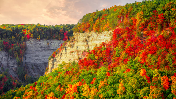
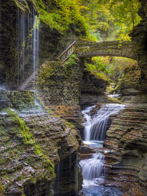
Ninety minutes south, the Genesee River has spent roughly twelve thousand years cutting a canyon 550 feet deep through shale and sandstone, and it put three waterfalls inside it. People call it the Grand Canyon of the East, which oversells the scale and undersells how close the railings let you stand.
It's open to you because one man bought it and gave it away with conditions. In 1859 a Buffalo businessman named William Pryor Letchworth purchased the land above the falls at Portage, built a house looking directly down at them, and spent the rest of his life there. In 1872 he hosted what turned out to be the last Seneca council fire at the old Council Grounds in the valley below; the Senecas gave him a name meaning the man who always does right, and a former US president came and planted a tree. Years later, when a hydroelectric dam was proposed at Portageville that would have drowned the falls, Letchworth fought it, then willed the whole estate to New York State on terms that stopped the dam for good. A gorge this size being undammed and public in the industrial Northeast is not an accident. It's somebody's will.
He also moved Mary Jemison's cabin and her grave to those Council Grounds, and her story is worth carrying in with you. She was taken captive as a girl during the French and Indian War, adopted by the Seneca, and offered her freedom years later. She declined it, stayed, raised her family along this river, and became known as the White Woman of the Genesee. Standing at her cabin turns the gorge from scenery into somewhere people actually lived.
The falls stack up over about three miles. Middle Falls is the one you'll remember: 107 feet across the full width of the river, close enough that you feel it in your sternum, and lit after dark. Upper Falls sits just above it with a railroad bridge arcing more than 200 feet overhead. Lower Falls is downstream in a narrow slot, quieter and reached on foot.
Letchworth's house is now the Glen Iris Inn, and you can have dinner on the porch he built to watch Middle Falls from. Very few state parks offer a 107-foot waterfall with your entrée.
Sixty-six miles of trails run through the park, the river runs high enough for whitewater rafting in spring, and hot air balloons launch from inside the gorge, which is either the best sixty minutes of your trip or an absolute no depending on your relationship with baskets. The best views are across the gorge rather than down into it, so long-range binoculars get more use here than anywhere else on this list.
Letchworth has its own campground, with electric but no sewer hookup, and New York State Parks enforces a two-night minimum. You'll dump on the way out, so bring a heavy-duty 20-foot sewer hose kit. Also worth knowing before you build a stay around it: campsite availability is reduced from summer 2026 through spring 2027 while the park puts in new shower buildings, with loops closing in phases. And Trail 7, from Middle Falls to the arch bridge, is permanently closed, though older guidebooks still route people onto it.
For most people on a five-day Niagara booking, the two-night minimum settles it. Go for the day. If gorge walking is the thing you came upstate for, the trails in our Niagara gorge hikes for RVers guide are forty minutes from camp instead of ninety.
Allegany State Park: Two Hours South, and the Only One Worth Moving For
Niagara is a place where you stand in a crowd and look at a thing. Allegany is 65,000 acres of hardwood ridge two hours south where you can walk for an hour and see nobody, and it looks the way it does because the ice missed it.
Almost every landscape in this article was scraped flat by the last glaciers. They stopped just short of here, which makes Allegany the one genuinely unglaciated corner of New York, and left it with the deep valleys and old exposed rock that everything to the north lost.
Thunder Rocks is what that looks like up close: a field of boulders the size of small houses standing on a wooded ridge, hard rock left behind as the softer ground around it wore away. It's the floor of a shallow sea that covered this country a few hundred million years ago, which is a good thing to mention to a child halfway up one. Kids reliably find a whale, a frog, a gorilla in the shapes. You climb on them. That's the whole activity and it's enough for two hours. Bear Caves nearby are narrow crevices in the same rock you can work your way into, cool and dark and mildly alarming in the correct way.
Most of what makes the park usable was built by hand during the Depression. Civilian Conservation Corps crews worked here from 1933 to 1942 out of seven separate camps, cutting roads and trails, throwing bridges across creeks, and putting up the Stone Tower, an observation platform on one of the high points that sits far enough from anything electric to be among the better places in the state to look at stars. Red House Lake handles the daylight version: a sandy beach, boat and bike rentals, and five miles of paved path looping the water. Pack the wheeled hard cooler, because there is not much out here in the way of concessions and that is most of the appeal.
Two hours south means four hours of driving to spend four hours in the woods. Move the RV. Allegany is the one place on this list that repays hauling everything down, and it has campgrounds to land in. The park doesn't post its length limits, so the only way to confirm one is to call directly. Do that before you tow anything down there, and check that a weight distribution hitch with sway control is properly adjusted first, because the grades south of Salamanca are real.
Where You're Driving Back To
Every drive time above is measured from Grand Island, where HTR Niagara sits with full hookups roughly twenty minutes from either the falls or Buffalo. Central to everything here, which is most of why it works as a base.
The alternative is Four Mile Creek up on the Lake Ontario shore: electric only, dump station, and Lake Ontario at the door. It adds fifteen or twenty minutes to every southbound drive in this article and gives you a sunset over water in exchange. Our Niagara waterfront for RVers guide covers what that trade actually buys.
Whichever one you're in, every drive here is a highway day, and a solar-charged tire pressure monitoring system tells you about a slow leak at mile 30 instead of mile 70.
Fitting These Day Trips From Niagara Falls Into Five Days
Lockport is the half day, and if your trip includes a weekend the free shuttle turns it into a half day that costs nothing to reach. Rochester is a full day and a genuinely different kind of one, urban and indoor and unlike everything else on the schedule. Letchworth wants a full day and will make you wish you'd given it two. Allegany wants you to hitch up and come stay.
Two open days at the end of a Niagara week is enough for one long drive and one short one. Pick the long one first, because the short one fits around anything. And if the answer turns out to be that you'd rather not leave at all, our free things to do in Niagara Falls guide fills those days without a ticket booth in sight.
Worth noticing, once you've done two or three of these: the falls are the loudest thing in this corner of the country but they aren't the reason anybody built here. The canal is. Lockport, Rochester and the mills and the money that followed all trace back to a ditch somebody blasted through a cliff in the 1820s, and you can go stand in it on a Tuesday.
FAQs
What are the best day trips from Niagara Falls?
Four destinations sit within two hours of the falls. Lockport is thirty minutes east, with a canal cruise that lifts your boat fifty feet through historic locks, and a free weekend shuttle that gets you there. Rochester is about 75 miles east and holds a downtown waterfall, the George Eastman Museum, and the Strong National Museum of Play, home of the World Video Game Hall of Fame. Letchworth State Park is ninety minutes south with a 550-foot gorge and three waterfalls. Allegany State Park is two hours south, 65,000 acres of forest left unglaciated by the last ice age. Two of the four have their own campgrounds, so each raises a choice between a day trip and moving the RV.
How far is Rochester from Niagara Falls?
About 75 miles east, or roughly ninety minutes on the Thruway. It works comfortably as a day trip without moving your RV. The draw is a real city rather than a tourist district: High Falls drops 96 feet into a gorge in the middle of downtown, the George Eastman Museum holds one of the world's great photography collections, and the Strong National Museum of Play holds the World Video Game Hall of Fame. Eat a garbage plate before you drive back.
How far is Letchworth State Park from Niagara Falls, and is it worth the drive?
Roughly ninety minutes south, and yes. The Genesee River has cut a canyon 550 feet deep with three waterfalls inside it, including the 107-foot Middle Falls, which you can stand alongside and which is lit at night. There are 66 miles of trails, hot air balloon flights over the gorge in season, and a historic inn perched directly above the falls where you can eat dinner. Most visitors staying at Niagara treat it as a full-day trip rather than a relocation.
Can you camp at Letchworth State Park in an RV?
Yes, with electric service and a dump station rather than sewer hookups at the site. Two things complicate it for anyone already booked at Niagara: the park enforces a two-night minimum, and campsite availability is reduced from summer 2026 through spring 2027 while new shower buildings go in, with loops closing in phases. Check availability before building a stay around it.
What is there to do in Lockport, New York?
Ride the locks. Lockport exists because the Erie Canal had to climb the Niagara Escarpment in the 1820s, a sixty-foot wall of solid rock between the canal and Lake Erie, and crews drilled and blasted a staircase of five locks into the cliff to get over it. A narrated canal cruise takes you through the modern working locks and raises the boat about fifty feet with rock walls on either side, and the restored original Flight of Five sits right alongside. The Erie Canal Discovery Center nearby explains how and why it was built. It's thirty minutes from the falls and reachable on a free shuttle on weekends in season.
Why was the Erie Canal important?
It opened in 1825 and ran 363 miles from the Hudson River at Albany to Lake Erie at Buffalo, the first practical freight route between the Atlantic and the American interior. Hauling a ton of goods from Buffalo to New York City had cost roughly a hundred dollars overland; the canal cut that to a small fraction and made New York City the busiest port in the country. It also built upstate New York: Rochester, Syracuse, Utica, Buffalo and Lockport are all canal towns, and two of the day trips in this guide are places the canal created.
Categories
Related Posts
Subscribe to the Swervia Newsletter
The best RV stories, tips, and destinations—expertly curated and always free.