Mt. Mansfield From an RV Base Camp: 3 Ways to Summit Vermont's Highest Peak
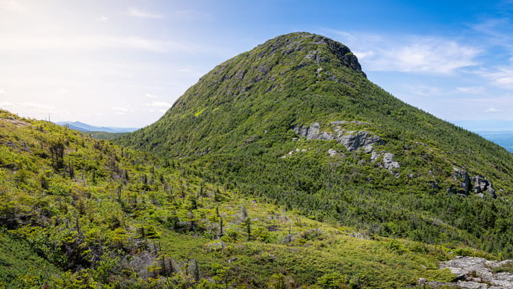
Mount Mansfield tops out at 4,395 feet, which makes it the highest ground in Vermont, and its long summit ridge is named like a face lying on its back: Forehead, Nose, Chin. The Chin is the true summit. There are three legitimate ways to stand on it, and choosing between them has less to do with your fitness than with what's parked at your campsite.
That's the part the trail guides leave out. The road to the top is open to cars only. The road connecting Stowe to the mountain's west-side trailhead carries a $1,000 fine if your vehicle is too long for it. And the state park sitting at the best trailhead has no RV sites at all. So before the routes, the vehicle.
If you came to Vermont to climb something hard, route three is waiting and it won't disappoint you. If you came with someone who isn't doing 2,300 feet of gain today, routes one and two aren't consolation prizes. They end at the same view.
First, Where the RV Actually Sleeps
Mansfield has no campground of its own. It has roads and trails on three sides and a scatter of campgrounds around the base, each useful to a different length of vehicle. Sort that out first, because it quietly decides which routes are even on the table, and our RV setup checklist covers getting settled fast enough that the first afternoon isn't gone before you've seen the mountain.
One date to hold onto: all three state parks below close on or near the second Monday in October, which is also roughly when the Toll Road and the gondola wind down. Vermont doesn't stagger its closing dates much.
Little River State Park, Waterbury
Little River State Park on the Waterbury Reservoir is the realistic base camp for Mansfield: 81 tent and RV sites, 20 lean-tos, five cabins, a sanitary dump station, and no hookups. The season runs from the third weekend in May through the third weekend in October, a slightly longer run than the parks up the valley get.
No hookups means the week is a battery-and-tank exercise, and a full trail day is a bad time to discover your amp-hour math was optimistic; our breakdown of how long you can boondock does that arithmetic. From the campground it's about 15 miles and 35 minutes to Stowe village, then another seven up Mountain Road to the Toll Road gate. The reservoir swimming is a genuinely good place to put your legs after a descent.
Smugglers' Notch State Park
Smugglers' Notch State Park sits closest to the east-side trailheads, and the state's own description doubles as the warning: because Route 108 north of the campground is narrow, the park has very few sites that can accommodate RVs. That isn't hedge language. It's 20 tent sites and 14 lean-tos on a road that gets tighter as it climbs. A van or a short trailer fits here and wakes up ten minutes from the Long Trail. A 34-footer shouldn't test it. The season runs the third weekend in May through the second Monday in October, and pets are welcome.
Smugglers' Notch RV Village, Jeffersonville
The only full-hookup option on this list, and the one whose address does the most explaining. Smugglers' Notch RV Village has 60 full-hookup sites with water, sewer, and either standard 20/30-amp or deluxe 20/30/50-amp service, plus pull-throughs, a camp store, a bathhouse, and a disc golf course for the afternoon nobody wants to move. Rates start at $69 a night or $449 a week, and the season runs May 1 through November 1, which outlasts every state park here by about three weeks.
Then the address. It's in Jeffersonville, on the far side of Smugglers' Notch from Stowe, and the park's own "just 20 minutes from Stowe" is a car number. Anything over the length limit reroutes about 35 miles and just under an hour around by Route 15 and Route 100, which is the same detour the Notch imposes on everyone else, just pointed the other direction.
Treat that as a feature if the west side is what you came for. From Jeffersonville the Underhill trailhead sits on your side of the mountain with no Notch in between, and the hour each way that Stowe-side campers pay for a morning on Sunset Ridge is an hour you've already spent.
Underhill State Park Is a Trailhead, Not a Base Camp
This one catches people, so here it is flatly: Underhill State Park has no RV camping. All 26 sites, 13 tent and 13 lean-to, are walk-in. No hookups, nothing you can back a trailer into, no version of this where you sleep at the west-side trailhead.
What it does have is the trailhead itself, day use from 8 a.m. to sunset, and a lot that fills on summer weekends. When it does, you park along Underhill's Mountain Road below the entrance and add the walk back up to your day. If the gate is closed, use the lot before it rather than improvising. The season runs from the Friday of Memorial Day weekend through the second Monday in October, and dogs are allowed.
The Smugglers' Notch Length Limit That Decides Your Trip
Vermont's transportation agency prohibits single vehicles over 40 feet and vehicle-and-trailer combinations over 45 feet on the Smugglers' Notch stretch of Route 108. Fines begin at $1,000 and rise above $4,000 for a second offense. This is state law, not a nervous suggestion posted by a small town.
Here's why it matters more than the number suggests. The Underhill trailhead is on the mountain's west side and Stowe is on the east. Ask a mapping app for the drive from Stowe village to Underhill State Park and it will hand you 28 miles up Mountain Road and straight over the Notch, because on a map that looks like the sensible line. Ask the same question from Little River State Park and you get 35 miles the other way, around the south end of the range on Route 2, Browns Trace, and Route 15, never touching the Notch at all. Roughly 70 minutes. The longer route is the legal one, and an over-length combination doesn't have a second option.
So, plainly: from an RV base camp on the Stowe side, the west side of Mansfield is an hour-plus commitment around the mountain. Worth it for a clear morning on Sunset Ridge. Not worth it for a maybe.
The Notch stretch also closes for winter, usually late October into November depending on the snow, which lands after everything else on this mountain has already shut. Check it before a late-season trip, not after you arrive.
Either way it comes down to the same thing: unhitch, or drive the tow vehicle. Every route below assumes you did.
Route 1: Drive the Mount Mansfield Auto Toll Road
The Auto Toll Road is 4.5 miles of winding gravel, about 20 minutes of climbing, ending at the Mount Mansfield Summit Station at 3,850 feet with a large parking lot. It's the lowest-effort way onto the mountain and, for most RV families, the one they'll actually take.
It is also, in the Stowe tourism office's own words, accessible to cars only. Leave the RV at camp and drive up in whatever you towed or towed with. There's no clever workaround here and no reading of that sentence where the trailer comes along.
Rates are $37 for the car plus $14 per passenger, so four people ride up for $79. The season runs late May through mid-October, weather permitting, and that clause is load-bearing: an exposed gravel switchback closes for conditions, not just for the calendar. There's no food at the top either, so a compartmented snack box for the summit earns its space in the back seat on a day like this.
From the Summit Station, the Green Mountain Club puts the Chin 1.4 miles north along the Long Trail with 546 feet of gain, rated moderate. Round trip with photo stops is a half day, not a full one. What $79 buys is the 2,300 feet of climbing you skipped, and nobody standing on the Chin can tell how you got there.
More Vermont RV intel where this came from. Subscribe to our weekly newsletter.
WHERE THE RV FITS AND WHERE TO STAY — FREE, EVERY WEDNESDAY.
Route 2: Ride the Stowe Gondola, Then Scramble the Cliff Trail
The Gondola SkyRide is the fastest way up and the most commonly misjudged. Summer and fall operation typically runs mid-June through mid-October, daily from 10 a.m., with reservations recommended and scheduled maintenance closures in spring and again in fall before ski season takes the mountain back.
The thing to know before buying a ticket: the gondola lands at the Cliff House, not the summit. There's a restaurant, a gift shop, a very good view, and the Chin still above you. Reaching it means the Cliff Trail, which the Green Mountain Club describes as 0.4 miles over very rugged terrain and steep ledges to the Long Trail, then another 0.04 to the top. The full round trip is about 1.6 miles with 700 feet of gain, and GMC rates it strenuous.
Set that against Route 1 for a second: the gondola finish is roughly a quarter the distance of the Toll Road walk and a harder piece of hiking. Plenty of travel pages file the gondola under easy and stop there. A gondola ticket isn't a summit ticket, and if ledges make anyone in the group go quiet, the Toll Road delivers the identical summit with none of the scrambling.
Parking at the base is resort parking, built for skiers' sedans in February rather than 30 feet of trailer in July. Same uncoupling as everywhere else here.
Route 3: Hike Mount Mansfield, and Pick Your Side
For anyone who came to do the actual climbing, Mansfield delivers on both sides. Which side you take is mostly a parking question.
Budget the day with the Green Mountain Club's formula: 30 minutes per mile plus 30 minutes per 1,000 feet of gain. Hell Brook at 3 miles and 2,300 feet comes to about two and a half hours of moving time, which is not the same as two and a half hours of daylight spent. Anyone who has done that math at a trailhead at 4 p.m. knows why it belongs at the front of the day.
East Side: Hell Brook and the Long Trail From Route 108
Hell Brook is roughly 3 miles round trip with 2,300 feet of gain, one of the most strenuous routes on the mountain and genuinely hazardous in wet weather. Parking is limited to the Big Spring lot about 150 feet south of the trailhead, which on a July Saturday means arriving early or driving away. Our guide to Stowe hikes for RVers sets it against the rest of the valley's trails if you want the fuller comparison.
The gentler hard option is the Long Trail south from Barnes Camp to the ridge and back down the Haselton Trail, about 5.8 miles with 2,800 feet of gain. Nearly double Hell Brook's distance for a similar climb, which is a trade most knees will take happily. It passes the Taft Lodge spur, a 300-foot detour to a shelter perched on a shelf below the Chin with the valley spread out underneath it.
If someone in the group isn't hiking at all, the Smugglers' Notch Boardwalk near Barnes Camp is 660 feet of accessible five-foot-wide boardwalk through wetlands, past a beaver dam, with interpretive panels and Notch views. It asks nothing of you, which some afternoons is the correct amount.
West Side: Sunset Ridge and Maple Ridge From Underhill State Park
The west side is the better hiking and the worse commute. From the Underhill trailhead, the Green Mountain Club's west-side loop links Maple Ridge up and Sunset Ridge down: 8.8 miles, 2,700 feet, rated difficult, extremely rugged and requiring hands in places. Laura Cowles splits off Sunset Ridge and offers a steeper, shorter alternative for one leg of it.
One warning matters more than the rest here, and it's for dog owners. The Maple Ridge Trail crosses a narrow, unbridged gap you have to leap, and GMC states plainly that many dogs and children aren't able to cross it. Plan the route around the dog rather than the reverse, and the answer is Sunset Ridge both directions.
For a half day instead of a full one, Cantilever Rock is 3.6 miles round trip with 1,200 feet of gain, rated moderate, and ends at a rock spear jutting horizontally out of a cliff face like it was set there on a dare.
Which Side, Given Where You Parked
For most RVers based on the Stowe side, it's the east side. Not because those trails are better, but because the west side costs 70 minutes each way around the range, and a two-hour round-trip drive bolted onto a five-hour hike turns a day into a campaign. If you're staying several nights and the forecast hands you one bluebird morning, spend it on Sunset Ridge. If you have exactly one big hike in you, spend it on the east side and put the saved hours on the reservoir.
This summit day slots into the full Stowe, Vermont RV itinerary if you're building the whole week around it. And if Mansfield leaves you wanting more, our Adirondack day hikes for RVers covers the nearest equivalent across Lake Champlain, sorted the same way as the Niagara gorge hikes for RVers.
What to Carry, and Where Not to Step
The Mansfield ridge holds some of the only true alpine tundra in Vermont, and those plants live on a margin that a single boot print erodes. GMC's instruction is direct: stay on the trail and avoid stepping on the rare and fragile alpine plants. Walk on rock, not on green.
That ridge sits at 4,395 feet with nothing between you and the weather. The Toll Road closes when conditions turn, which is a reasonable standard to borrow. If the road wouldn't go up, neither should you. Clouds reach that ridge considerably faster than the parking lot suggests.
There's no water and no dining at the Summit Station, so you carry what you drink. An insulated bottle that survives a pack holds temperature through a summer ridge walk better than the one rolling around a cupholder, and back at a site with no hookups, a gravity filter for refilling at camp keeps the tank math from getting tight by Thursday.
Dogs are welcome at both Underhill and Smugglers' Notch State Parks, but the Maple Ridge gap and the Cliff Trail ledges are limits rather than challenges. Pick the route for the dog.
Then the thing nobody packs: something dry to change into. Descending 2,300 feet in soaked socks is its own kind of memory, and high-cushion ankle socks plus a quick-dry towel that clips to a pack are the difference between a comfortable drive back to camp and a very quiet one. Your camp chair deserves a dry version of you.
FAQs
Can you drive an RV up Mount Mansfield?
No. The Auto Toll Road is accessible to cars only, per the Stowe tourism office, so the RV stays at camp and you drive up in the tow vehicle or the towed car. The road climbs 4.5 miles of steep gravel in about 20 minutes to the Mount Mansfield Summit Station at 3,850 feet. From there it's 1.4 miles north along the Long Trail, 546 feet of gain, to the Chin: the true summit at 4,395 feet and the highest point in Vermont.
Does the Stowe gondola take you to the summit of Mount Mansfield?
No. The Gondola SkyRide reaches the Cliff House, which has a restaurant and a wide view but sits below the summit. Reaching the Chin means the Cliff Trail, 0.4 miles over very rugged terrain and steep ledges to the Long Trail, then another 0.04 to the top. The Green Mountain Club rates that 1.6-mile round trip with 700 feet of gain as strenuous, making it the shortest route up and one of the most technical. Anyone uneasy on ledges should take the Toll Road instead.
Can you take an RV through Smugglers' Notch?
Not if it's over the limits. Vermont law prohibits single vehicles longer than 40 feet and vehicle-and-trailer combinations longer than 45 feet on the Smugglers' Notch stretch of Route 108, with fines starting at $1,000 and exceeding $4,000 for a second offense. Mapping apps route drivers into it constantly because it looks like the direct line between Stowe and the west side of the mountain. From Little River State Park, the legal route to the Underhill trailhead runs about 35 miles and 70 minutes around the south end of the range via Route 2 and Route 15.
Is there RV camping at Underhill State Park?
No. All 26 sites at Underhill State Park are walk-in, 13 tent and 13 lean-to, with no hookups and no RV sites at all. It's the west-side trailhead with a day-use lot, open 8 a.m. to sunset, and that lot fills on summer weekends. For RV camping, Little River State Park in Waterbury has 81 tent and RV sites with a dump station and no hookups, Smugglers' Notch State Park has a few that fit smaller RVs, and Smugglers' Notch RV Village in Jeffersonville has 60 full-hookup sites on the far side of the Notch.
How long does it take to hike Mount Mansfield?
Use the Green Mountain Club's formula: 30 minutes per mile plus 30 minutes per 1,000 feet of gain. Hell Brook at 3 miles round trip and 2,300 feet comes to roughly two and a half hours of moving time. The Long Trail from Barnes Camp down the Haselton Trail, 5.8 miles and 2,800 feet, comes to about four and a half. Add breaks and photos, then start early enough that the math still works if the day runs slow.
How much does the Mount Mansfield Toll Road cost, and when is it open?
The posted rate is $37 per car plus $14 per additional passenger, so a family of four rides up for $79. It's open late May through mid-October, weather permitting, and closes for conditions as well as for the calendar. There's no food at the top, so bring a picnic. Everything else here shuts in the same tight October window, gondola and all three nearby state parks included.
Can you bring a dog up Mount Mansfield?
Yes, and dogs are permitted at both Underhill and Smugglers' Notch State Parks, but the route matters. Avoid the Maple Ridge Trail on the west side, which crosses a narrow unbridged gap that many dogs and children can't cross, and skip the Cliff Trail's steep ledges above the gondola. Sunset Ridge from Underhill and the Long Trail ridge walk from the Toll Road lot are the better options, and the alpine summit means keeping the dog on the trail and off the plants.
Categories
Related Posts
Subscribe to the Swervia Newsletter
The best RV stories, tips, and destinations—expertly curated and always free.